GeotchaA geography quiz on a real globe
US states
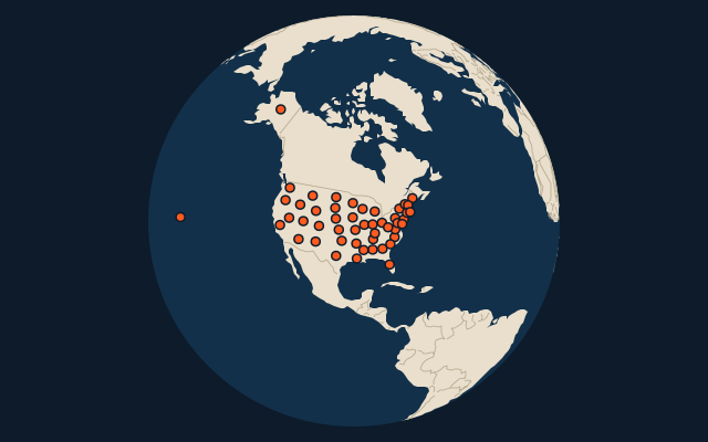
50 states, each one drawn on a satellite globe. Name it when it lights up, find it when you are given its name, tell its flag from three others, or type every one you can remember in Name all.
All 50 states, largest first. Free to start: a few quizzes a day cost nothing, and Geotcha Plus opens every quiz. What you miss comes back for review until it sticks.
New to these? Read the guide first: How to learn the 50 US states.
The full list
About this quiz
Alaska is the largest of the 50 states in this quiz, at 1,717,856 km²; Rhode Island is the smallest listed, at 4,001 km². Alaska's area is 2.5 times Texas's (696,241 km²). The three largest hold 29% of the combined area of all 50.
What they are known for
- Alaska: Bought from Russia in 1867; Denali towers here, and the Aleutian chain trails toward Siberia.
- Texas: Was an independent republic from 1836 to 1845; the Alamo stands in San Antonio, and its flag has one star.
- California: Home to Hollywood, Silicon Valley and the Golden Gate Bridge; the Gold Rush started here in 1848.
- Montana: Big Sky Country; Glacier National Park lies on its northern border and Yellowstone spills into its south.
- New Mexico: Los Alamos, Roswell's alien legend and the Trinity atomic test site are all here; its nickname is Land of Enchantment.
- Arizona: Holds the Grand Canyon and forests of saguaro cacti; most of it ignores daylight saving time.
- Nevada: Driest state; Las Vegas casinos and Reno are its big cities, and Hoover Dam sits on its edge.
- Colorado: A near-perfect rectangle with Denver, the Rocky Mountains and Pikes Peak; mile-high capital.
The states
- 1Alaska1,717,856 km²
- 2Texas696,241 km²
- 3California423,970 km²
- 4Montana381,154 km²
- 5New Mexico315,194 km²
- 6Arizona295,234 km²
- 7Nevada286,380 km²
- 8Colorado269,837 km²
- 9Oregon255,026 km²
- 10Wyoming253,348 km²
- 11Michigan250,493 km²
- 12Minnesota225,163 km²
- 13Utah219,653 km²
- 14Idaho216,699 km²
- 15Kansas213,100 km²
- 16Nebraska200,520 km²
- 17South Dakota199,729 km²
- 18Washington184,827 km²
- 19North Dakota183,108 km²
- 20Oklahoma181,195 km²
- 21Missouri180,533 km²
- 22Florida170,304 km²
- 23Wisconsin169,640 km²
- 24Georgia153,909 km²
- 25Illinois149,998 km²
- 26Iowa145,746 km²
- 27New York141,300 km²
- 28North Carolina139,390 km²
- 29Arkansas137,733 km²
- 30Alabama135,765 km²
- 31Louisiana135,382 km²
- 32Mississippi125,443 km²
- 33Pennsylvania119,283 km²
- 34Ohio116,096 km²
- 35Virginia110,862 km²
- 36Tennessee109,247 km²
- 37Kentucky104,659 km²
- 38Indiana94,321 km²
- 39Maine91,646 km²
- 40South Carolina82,931 km²
- 41West Virginia62,755 km²
- 42Maryland32,131 km²
- 43Hawaii28,311 km²
- 44Massachusetts27,336 km²
- 45Vermont24,923 km²
- 46New Hampshire24,214 km²
- 47New Jersey22,591 km²
- 48Connecticut14,357 km²
- 49Delaware6,452 km²
- 50Rhode Island4,001 km²
On the map
By continent and rank
- 50 largest regions in the world
- 50 most populous regions in the world
- Every state, province and region of the world
- 25 largest regions in Africa
- Every state, province and region of Africa
- 25 largest regions in Asia
- Every state, province and region of Asia
- 25 largest regions in Europe
- Every state, province and region of Europe
- 25 largest regions in North America
- Every state, province and region of North America
- 25 largest regions in South America
More sets
- Countries of the world
- World capitals
- Bodies of water
- Straits & channels
- Continents and oceans
- Longest river systems
- Largest lakes
- Largest islands
- Famous peaks
- Famous volcanoes
- Mountain ranges
- Largest deserts
- Provinces of China
- Counties of England
- The 32 counties of Ireland
- Regions bigger than countries
- Largest cities of the world
- Largest cities of China
- Largest cities of Egypt
- Europe’s 5 shortest land borders
- The 10 closest pairs of capitals
How the figures are measured
The 50 states of the United States; Washington, D.C. and the territories (Puerto Rico, Guam, etc.) are not states and are excluded. Area in km² is total area including inland, coastal and Great Lakes water (US Census Bureau), so Michigan ranks far higher than its land area alone would put it. Hawaii is filed under North America with the other states.