GeotchaA geography quiz on a real globe
Every state, province and region of the world
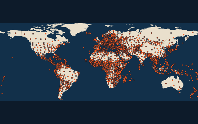
3,927 regions, each one drawn on a satellite globe. Name it when it lights up, find it when you are given its name, or type every one you can remember in Name all.
Free to play, with no account needed. What you miss comes back for review until it sticks.
The regions
- 1Sakha Republic3,083,523 km²
- 2Western Australia2,527,013 km²
- 3Krasnoyarsk Krai2,339,700 km²
- 4Nunavut2,038,722 km²
- 5Queensland1,729,742 km²
- 6Alaska1,717,856 km²
- 7Xinjiang1,664,897 km²
- 8Amazonas1,559,168 km²
- 9Quebec1,542,056 km²
- 10Northern Territory1,347,791 km²
- 11Northwest Territories1,346,106 km²
- 12Pará1,245,871 km²
- 13Tibet1,228,400 km²
- 14Inner Mongolia1,181,104 km²
- 15Ontario1,076,395 km²
- 16South Australia984,321 km²
- 17British Columbia944,735 km²
- 18Mato Grosso903,357 km²
- 19New South Wales801,150 km²
- 20Khabarovsk Krai787,633 km²
- 21Irkutsk774,846 km²
- 22Chukotka Autonomous Okrug721,481 km²
- 23Qinghai696,700 km²
- 24Texas696,241 km²
- 25Yamalo-Nenets Autonomous Okrug683,976 km²
- 26Eastern672,522 km²
- 27Agadez667,799 km²
- 28Alberta661,848 km²
- 29Saskatchewan651,900 km²
- 30Manitoba647,797 km²
- 31Minas Gerais586,514 km²
- 32Bahia565,733 km²
- 33Khanty-Mansi Autonomous Okrug534,500 km²
- 34Sichuan485,000 km²
- 35Yukon482,443 km²
- 36Kamchatka Krai472,300 km²
- 37Magadan465,464 km²
- 38Heilongjiang454,800 km²
- 39Gansu454,000 km²
- 40New Valley435,128 km²
- 41Zabaykalsky Krai431,500 km²
- 42California423,970 km²
- 43Kufra420,389 km²
- 44Komi Republic416,800 km²
- 45Riyadh412,000 km²
- 46Taoudénit410,019 km²
- 47Newfoundland and Labrador405,212 km²
- 48Arkhangelsk401,381 km²
- 49Yunnan394,100 km²
- 50Montana381,154 km²
- 51Northern Cape372,889 km²
- 52Santa Cruz370,621 km²
- 53Loreto368,773 km²
- 54Northern367,538 km²
- 55Tamanrasset366,673 km²
- 56Amur361,913 km²
- 57Mato Grosso do Sul357,146 km²
- 58Republic of Buryatia351,300 km²
- 59Balochistan347,190 km²
- 60Rajasthan342,269 km²
and 3,867 more, all in the quiz.
Area in km²: Wikidata’s figure (P2046, the whole or the land area, whichever matches the outline) where it is within a factor of two of the outline’s area; the official area where the national statistics office gives one (countries whose divisions changed since Natural Earth); else the area measured on the outline. Each item names its source. Sources: Natural Earth 1:10m admin-1 (public domain), OpenStreetMap (ODbL), Wikidata (CC0), national statistics offices.
On the map
More of the world
- 25 largest cities in the world
- 25 largest countries in the world
- 50 largest regions in the world
- 25 largest lakes in the world
- 25 longest rivers in the world
- 25 highest peaks in the world
- 25 largest islands in the world
- 25 longest fjords in the world
- Flags of the world
- 50 largest cities in the world