GeotchaA geography quiz on a real globe
50 most populous regions in the world
50 regions, each one drawn on a satellite globe. Name it when it lights up, find it when you are given its name, or type every one you can remember in Name all.
Free to start: a few quizzes a day cost nothing, and Geotcha Plus opens every quiz. What you miss comes back for review until it sticks.
The full list
About this quiz
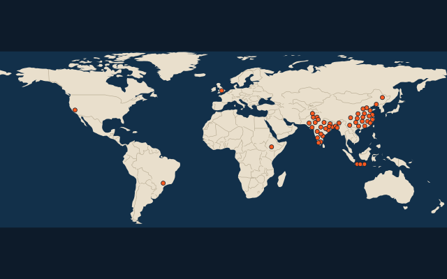
Uttar Pradesh is the largest of the 50 regions in this quiz, at 252.9 M; Haryana is the smallest listed, at 31 M. Uttar Pradesh's population is about twice Maharashtra's (133.9 M). The three largest hold 16% of the combined population of all 50. They lie in nine countries; China has the most, with 20.
What they are known for
- Uttar Pradesh: Most populous state, with the Taj Mahal, holy Varanasi on the Ganges, Ayodhya and Lucknow's kebabs.
- Maharashtra: Western state of Mumbai, Bollywood, the Ajanta and Ellora cave temples, Deccan plateau and Western Ghats.
- Punjab (Pakistan): Land of five rivers and the most populous province, with wheat fields, Lahore's Badshahi Mosque and Mughal Fort.
- Guangdong: Most populous province, home of Cantonese food and the Pearl River Delta factories.
- Bihar: Eastern Gangetic plain state of Bodh Gaya, where Buddha attained enlightenment, ancient Nalanda and Chhath festival.
- West Bengal: Eastern state of Kolkata, Darjeeling tea, the Sundarbans mangrove tigers, rasgulla sweets and Durga Puja.
- Shandong: Birthplace of Confucius; Mount Tai and Qingdao are here.
- Henan: Ancient capitals Luoyang and Kaifeng and the Shaolin Temple lie here.
The regions
- 1Uttar Pradesh India252.9 M
- 2Maharashtra India133.9 M
- 3Punjab (Pakistan) Pakistan131.7 M
- 4Guangdong China125.7 M
- 5Bihar India123.7 M
- 6West Bengal India108.8 M
- 7Shandong China101.3 M
- 8Henan China99.1 M
- 9Madhya Pradesh India86.5 M
- 10Tamil Nadu India86 M
- 11Jiangsu China84.6 M
- 12Sichuan China83.5 M
- 13Rajasthan India81.7 M
- 14Hebei China74.4 M
- 15Karnataka India72.9 M
- 16Gujarat India72 M
- 17Hunan China66.3 M
- 18Zhejiang China64.4 M
- 19Anhui China60.9 M
- 20England United Kingdom58.8 M
- 21Hubei China57.6 M
- 22Sindh Pakistan57.4 M
- 23Andhra Pradesh India55 M
- 24Oromia Ethiopia51.9 M
- 25West Java Indonesia50.8 M
- 26Odisha India50 M
- 27Guangxi China50 M
- 28Dhaka Bangladesh47.2 M
- 29Yunnan China47.1 M
- 30São Paulo Brazil46.5 M
- 31Jiangxi China45.1 M
- 32Liaoning China42.5 M
- 33Khyber Pakhtunkhwa Pakistan42.1 M
- 34East Java Indonesia42.1 M
- 35Telangana India41.9 M
- 36Fujian China41.4 M
- 37California United States40.8 M
- 38Shaanxi China39.4 M
- 39Jharkhand India39.3 M
- 40Guizhou China38.5 M
- 41Central Java Indonesia38.2 M
- 42Kerala India38.2 M
- 43Assam India37.2 M
- 44Chittagong Bangladesh35.4 M
- 45Shanxi China34.8 M
- 46Punjab (India) India33.1 M
- 47Chongqing China32 M
- 48Heilongjiang China31.8 M
- 49Chhattisgarh India31.5 M
- 50Haryana India31 M
On the map
More of the world
- 25 largest cities in the world
- 25 largest countries in the world
- 50 largest regions in the world
- 25 largest lakes in the world
- 25 longest rivers in the world
- 25 highest peaks in the world
- 25 largest islands in the world
- 25 longest fjords in the world
- Flags of the world
- 50 largest cities in the world
How the figures are measured
Population of each region: for countries whose divisions changed since Natural Earth, the figure of the national statistics office, as each item names it; a 2025 estimate: the latest official figure (a census or an estimate, as each item names it) scaled with the rest of its country’s regions to the World Bank’s 2025 national total, so a country’s regions share one year. Each item names its source and year. Regions without a figure are left out.