GeotchaA geography quiz on a real globe
Straits & channels
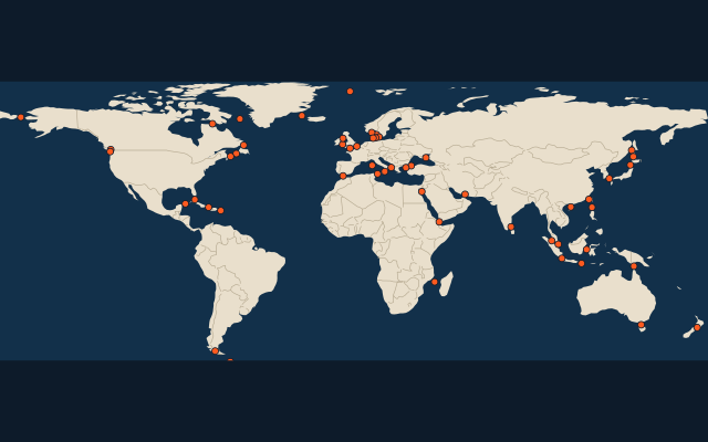
53 straits, each one drawn on a satellite globe. Name it when it lights up, find it when you are given its name, or type every one you can remember in Name all.
53 straits, channels & passages that join the seas. Free to start: a few quizzes a day cost nothing, and Geotcha Plus opens every quiz. What you miss comes back for review until it sticks.
The full list
About this quiz
The quiz covers 53 straits, from Strait of Hormuz and Bosporus to Northumberland Strait. They lie in 29 countries; Denmark and Canada have the most, six each.
What they are known for
- Strait of Hormuz: In normal times about a fifth of the world's oil passes through this chokepoint, barely 40 km wide.
- Bosporus: A city of 15 million straddles it, with bridges linking two continents.
- English Channel: Crossed by a 50 km rail tunnel since 1994; the French call it 'the sleeve'.
- Strait of Gibraltar: The ancients placed the Pillars of Hercules on either side of it.
- Bering Strait: A land bridge here let the first people walk from Asia into the Americas; the date line runs down its middle.
- Dardanelles: Scene of a failed Allied naval and land campaign in 1915; ancient Troy stood near its southern mouth.
- Strait of Malacca: The busiest shipping lane between the Indian and Pacific oceans, long plagued by pirates.
- Strait of Magellan: First sailed by Europeans in 1520, on the voyage that became the first circumnavigation.
The straits
- 1Strait of Hormuz Iran
- 2Bosporus Turkey
- 3English Channel United Kingdom
- 4Strait of Gibraltar Spain
- 5Bering Strait Russia
- 6Dardanelles Turkey
- 7Strait of Malacca Malaysia
- 8Strait of Magellan Chile
- 9Bab-el-Mandeb Yemen
- 10Mozambique Channel Mozambique
- 11Kattegat Denmark
- 12Skagerrak Norway
- 13Taiwan Strait China
- 14Drake Passage Chile
- 15Kerch Strait Russia
- 16Korea Strait South Korea
- 17Strait of Dover United Kingdom
- 18Strait of Otranto Italy
- 19Bass Strait Australia
- 20Sunda Strait Indonesia
- 21Oresund Denmark
- 22Denmark Strait Denmark
- 23Torres Strait Australia
- 24Davis Strait Canada
- 25Cook Strait New Zealand
- 26Strait of Messina Italy
- 27Palk Strait India
- 28Makassar Strait Indonesia
- 29Straits of Florida United States
- 30Tsugaru Strait Japan
- 31Strait of Tartary Russia
- 32Hudson Strait Canada
- 33La Pérouse Strait Russia
- 34Yucatán Channel Mexico
- 35St George's Channel Ireland
- 36Strait of Tiran Egypt
- 37Singapore Strait Singapore
- 38Strait of Sicily Italy
- 39North Channel United Kingdom
- 40Great Belt Denmark
- 41Strait of Bonifacio France
- 42Little Belt Denmark
- 43Lombok Strait Indonesia
- 44Luzon Strait Philippines
- 45Strait of Georgia Canada
- 46Fram Strait Denmark
- 47Windward Passage Cuba
- 48Strait of Juan de Fuca United States
- 49Qiongzhou Strait China
- 50Strait of Belle Isle Canada
- 51Cabot Strait Canada
- 52Mona Passage Dominican Republic
- 53Northumberland Strait Canada
On the map
More sets
- Countries of the world
- World capitals
- Bodies of water
- Continents and oceans
- Longest river systems
- Largest lakes
- Largest islands
- Famous peaks
- Famous volcanoes
- Mountain ranges
- Largest deserts
- US states
- Provinces of China
- Counties of England
- The 32 counties of Ireland
- Regions bigger than countries
- Largest cities of the world
- Largest cities of China
- Largest cities of Egypt
- Europe’s 5 shortest land borders
- The 10 closest pairs of capitals
How the figures are measured
Ranked by how many Wikipedia language editions have an article on each one (Wikidata sitelinks, September 2026), a proxy for how well known it is. Outlines follow Natural Earth 1:10m marine polygons where they exist, else OpenStreetMap or Marine Regions; the rest are cut from the Natural Earth 1:10m coastline between each strait's usual end lines.