GeotchaA geography quiz on a real globe
Largest islands
100 islands, each one drawn on a satellite globe. Name it when it lights up, find it when you are given its name, or type every one you can remember in Name all.
100 of the largest islands by area. Free to start: a few quizzes a day cost nothing, and Geotcha Plus opens every quiz. What you miss comes back for review until it sticks.
The full list
About this quiz
Greenland is the largest of the 100 islands in this quiz, at 2,166,086 km²; Wellington Island is the smallest listed, at 5,556 km². Greenland's area is 2.8 times New Guinea's (785,753 km²). The three largest hold 41% of the combined area of all 100. They lie in 30 countries; Canada has the most, with 23.
What they are known for
- Greenland: Mostly buried under an ice sheet; a self-governing Danish territory with Nuuk as its capital.
- New Guinea: Shared between Indonesia and an independent Pacific nation; over 800 languages are spoken here.
- Borneo: Shared by Indonesia, Malaysia and Brunei; rainforest home of orangutans and pygmy elephants.
- Madagascar: Lemurs, baobabs and chameleons; split from India long ago, so most of its wildlife exists nowhere else.
- Baffin Island: Biggest island of Canada, with Iqaluit, the capital of Nunavut, on its south-eastern coast.
- Sumatra: Tigers, rhinos, elephants and orangutans all live here; Banda Aceh at its tip was devastated by the 2004 tsunami.
- Honshu: Japan's main island, home to Tokyo, Kyoto, Hiroshima and Mount Fuji.
- Victoria Island: Canadian Arctic island split between Nunavut and the Northwest Territories, with the hamlets of Cambridge Bay and Ulukhaktok.
The islands
- 1Greenland Denmark2,166,086 km²
- 2New Guinea Indonesia785,753 km²
- 3Borneo Indonesia748,168 km²
- 4Madagascar587,713 km²
- 5Baffin Island Canada507,451 km²
- 6Sumatra Indonesia473,481 km²
- 7Honshu Japan227,940 km²
- 8Victoria Island Canada217,291 km²
- 9Great Britain United Kingdom209,331 km²
- 10Ellesmere Island Canada196,235 km²
- 11Sulawesi Indonesia174,600 km²
- 12South Island New Zealand150,437 km²
- 13Java Indonesia128,297 km²
- 14North Island New Zealand113,729 km²
- 15Luzon Philippines109,965 km²
- 16Newfoundland Canada108,860 km²
- 17Cuba105,806 km²
- 18Iceland102,775 km²
- 19Mindanao Philippines97,530 km²
- 20Ireland84,421 km²
- 21Hokkaido Japan77,984 km²
- 22Hispaniola Haiti76,420 km²
- 23Sakhalin Russia72,492 km²
- 24Banks Island Canada70,028 km²
- 25Sri Lanka67,655 km²
- 26Tasmania Australia65,022 km²
- 27Devon Island Canada55,247 km²
- 28Isla Grande de Tierra del Fuego Argentina47,992 km²
- 29Severny Island Russia47,079 km²
- 30Axel Heiberg Island Canada43,178 km²
- 31Melville Island Canada42,149 km²
- 32Southampton Island Canada41,214 km²
- 33Marajó Brazil40,100 km²
- 34Spitsbergen Norway37,673 km²
- 35Kyushu Japan36,782 km²
- 36New Britain Papua New Guinea36,520 km²
- 37Taiwan35,883 km²
- 38Prince of Wales Island Canada33,339 km²
- 39Yuzhny Island Russia33,275 km²
- 40Hainan China33,210 km²
- 41Vancouver Island Canada32,134 km²
- 42Timor Timor-Leste30,777 km²
- 43Sicily Italy25,662 km²
- 44Somerset Island Canada24,786 km²
- 45Sardinia Italy23,949 km²
- 46Kotelny Island Russia23,200 km²
- 47Bananal Island Brazil19,162 km²
- 48Shikoku Japan18,297 km²
- 49Halmahera Indonesia17,780 km²
- 50Seram Indonesia17,454 km²
- 51New Caledonia France16,372 km²
- 52Bathurst Island Canada16,042 km²
- 53Prince Patrick Island Canada15,848 km²
- 54Nordaustlandet Norway14,443 km²
- 55Sumbawa Indonesia14,386 km²
- 56October Revolution Island Russia14,204 km²
- 57Flores Indonesia13,540 km²
- 58Samar Philippines13,429 km²
- 59King William Island Canada13,111 km²
- 60Negros Philippines13,075 km²
and 40 more islands, all in the quiz.
On the map
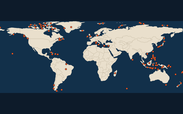
By continent and rank
- 25 largest islands in the world
- 50 largest islands in the world
- 100 largest islands in the world
- Islands ranked 101–200 in the world
- 25 largest islands in Africa
- 25 largest islands in Asia
- Islands in Asia among the world’s 100 largest
- 25 largest islands in Europe
- Islands in Europe among the world’s 100 largest
- 25 largest islands in North America
- Islands in North America among the world’s 100 largest
- 25 largest islands in South America
More sets
- Countries of the world
- World capitals
- Bodies of water
- Straits & channels
- Continents and oceans
- Longest river systems
- Largest lakes
- Famous peaks
- Famous volcanoes
- Mountain ranges
- Largest deserts
- US states
- Provinces of China
- Counties of England
- The 32 counties of Ireland
- Regions bigger than countries
- Largest cities of the world
- Largest cities of China
- Largest cities of Egypt
- Europe’s 5 shortest land borders
- The 10 closest pairs of capitals
How the figures are measured
100 of the largest islands, not counting Antarctica's ice-covered islands unless they are included (Wikipedia's list of islands by area): land area in km² of the single island (not the island group or the country on it; continental landmasses such as Australia excluded). Areas are Wikidata's, or the island's own figure where Wikidata measures something else (a territory, an archipelago). River islands are not on it, as no land outline draws them: Tupinambarana in the Amazon (11,850 km²) and Arga-Muora-Sise in the Lena delta (6,400 km²), which the islands pool lists as points, so its 100 largest differ from this list by those two. Two islands are called Melville: the Canadian one in the Arctic (42,149 km²) and Australia's Tiwi island (5,765 km²), both listed.