GeotchaA geography quiz on a real globe
Regions bigger than countries
25 regions, each one drawn on a satellite globe. Name it when it lights up, find it when you are given its name, tell its flag from three others, or type every one you can remember in Name all.
The 25 largest states, provinces and territories in the world. Free to start: a few quizzes a day cost nothing, and Geotcha Plus opens every quiz. What you miss comes back for review until it sticks.
The full list
About this quiz
Sakha is the largest of the 25 regions in this quiz, at 3,083,523 km²; Texas is the smallest listed, at 695,662 km². The three largest hold 24% of the combined area of all 25. They lie in six countries; Russia has the most, with six.
What they are known for
- Sakha: Russia's coldest inhabited republic, crossed by the Lena; Yakutsk is its capital.
- Western Australia: A third of a continent, from the Kimberley to the Nullarbor; Perth is its capital.
- Krasnoyarsk Krai: Siberian territory along the Yenisei from the Sayan Mountains to the Taymyr Peninsula.
- Nunavut: Canada's Inuit territory of Arctic islands and tundra; Iqaluit is its capital.
- Queensland: North-east Australian state with the Great Barrier Reef; Brisbane is its capital.
- Alaska: The northwestern US state across the Bering Strait from Russia; Juneau is its capital.
- Xinjiang: China's far west, bordering eight countries; Ürümqi is its capital.
- Amazonas: Brazil's rainforest state where the Negro meets the Solimões; Manaus is its capital.
The regions
- 1Sakha Russia3,083,523 km²
- 2Western Australia Australia2,527,013 km²
- 3Krasnoyarsk Krai Russia2,366,797 km²
- 4Nunavut Canada2,093,190 km²
- 5Queensland Australia1,729,742 km²
- 6Alaska United States1,723,337 km²
- 7Xinjiang China1,664,900 km²
- 8Amazonas Brazil1,558,704 km²
- 9Québec Canada1,542,056 km²
- 10Northern Territory Australia1,347,791 km²
- 11Northwest Territories Canada1,346,106 km²
- 12Pará Brazil1,245,832 km²
- 13Tibet China1,202,800 km²
- 14Inner Mongolia China1,183,000 km²
- 15Ontario Canada1,076,395 km²
- 16South Australia Australia984,321 km²
- 17British Columbia Canada944,735 km²
- 18Mato Grosso Brazil903,208 km²
- 19New South Wales Australia801,150 km²
- 20Khabarovsk Krai Russia787,633 km²
- 21Irkutsk Oblast Russia774,846 km²
- 22Yamalo-Nenets Russia769,250 km²
- 23Qinghai China722,300 km²
- 24Chukotka Russia721,481 km²
- 25Texas United States695,662 km²
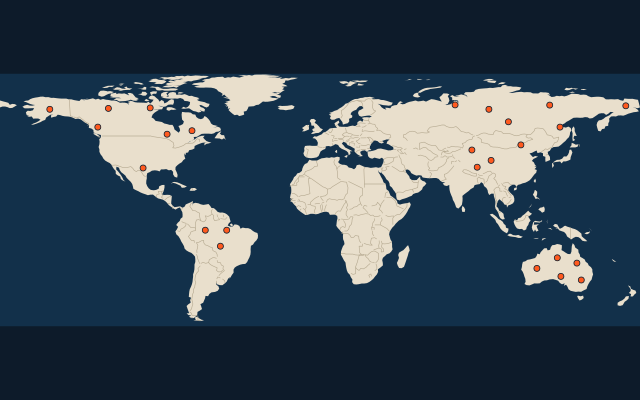
On the map
More sets
- Countries of the world
- World capitals
- Bodies of water
- Straits & channels
- Continents and oceans
- Longest river systems
- Largest lakes
- Largest islands
- Famous peaks
- Famous volcanoes
- Mountain ranges
- Largest deserts
- US states
- Provinces of China
- Counties of England
- The 32 counties of Ireland
- Largest cities of the world
- Largest cities of China
- Largest cities of Egypt
- Europe’s 5 shortest land borders
- The 10 closest pairs of capitals
How the figures are measured
First-level regions of a country (states, provinces, territories, autonomous regions, federal subjects) of at least Texas's official total area, ranked by the official total area of each country's statistics or mapping office, not by the drawn outlines. Total area: land and inland water for Canada (NRCan) and the US (Census); mainland plus islands for Australia (Geoscience Australia); the official regional figures for Russia (Rosstat, Rosreestr cadastre), China (the regional governments and the National Ethnic Affairs Commission) and Brazil (IBGE, 2025 edition). Antarctic claims are excluded, and Greenland, which the app counts as a country, is not a region here. Tyumen Oblast is counted without its two autonomous okrugs, which are federal subjects of their own (Yamalo-Nenets is one). The Northern Territory edges out the Northwest Territories by about 1,700 km² on these figures.