GeotchaA geography quiz on a real globe
Islands in North America among the world’s 100 largest
31 islands, each one drawn on a satellite globe. Name it when it lights up, find it when you are given its name, or type every one you can remember in Name all.
Free to start: a few quizzes a day cost nothing, and Geotcha Plus opens every quiz. What you miss comes back for review until it sticks.
The full list
About this quiz
Greenland is the largest of the 31 islands in this quiz, at 2,166,086 km²; Prince Edward Island is the smallest listed, at 5,620 km². Greenland's area is 4.3 times Baffin Island's (507,451 km²). The three largest hold 75% of the combined area of all 31. Canada has 23 of the 31, in a list that spans six countries.
What they are known for
- Greenland: Mostly buried under an ice sheet; a self-governing Danish territory with Nuuk as its capital.
- Baffin Island: Biggest island of Canada, with Iqaluit, the capital of Nunavut, on its south-eastern coast.
- Victoria Island: Canadian Arctic island split between Nunavut and the Northwest Territories, with the hamlets of Cambridge Bay and Ulukhaktok.
- Ellesmere Island: Canada's northernmost island, with Alert, the most northerly permanently inhabited place on Earth.
- Newfoundland: Norse settlers built L'Anse aux Meadows here around the year 1000, the only confirmed Norse site in North America outside Greenland.
- Cuba: Caribbean island known for cigars, vintage American cars and its capital Havana.
- Hispaniola: Shared by Haiti and the Dominican Republic; Columbus founded the first Spanish settlement in the Americas here.
- Banks Island: Arctic island with Sachs Harbour as its only community and one of the densest muskox herds on Earth.
The islands
- 1Greenland Denmark2,166,086 km²
- 2Baffin Island Canada507,451 km²
- 3Victoria Island Canada217,291 km²
- 4Ellesmere Island Canada196,235 km²
- 5Newfoundland Canada108,860 km²
- 6Cuba105,806 km²
- 7Hispaniola Haiti76,420 km²
- 8Banks Island Canada70,028 km²
- 9Devon Island Canada55,247 km²
- 10Axel Heiberg Island Canada43,178 km²
- 11Melville Island Canada42,149 km²
- 12Southampton Island Canada41,214 km²
- 13Prince of Wales Island Canada33,339 km²
- 14Vancouver Island Canada32,134 km²
- 15Somerset Island Canada24,786 km²
- 16Bathurst Island Canada16,042 km²
- 17Prince Patrick Island Canada15,848 km²
- 18King William Island Canada13,111 km²
- 19Ellef Ringnes Island Canada11,295 km²
- 20Jamaica11,190 km²
- 21Bylot Island Canada11,067 km²
- 22Cape Breton Island Canada10,311 km²
- 23Prince Charles Island Canada9,521 km²
- 24Kodiak Island United States9,310 km²
- 25Puerto Rico United States8,868 km²
- 26Disko Island Denmark8,612 km²
- 27Anticosti Island Canada7,941 km²
- 28Cornwallis Island Canada6,995 km²
- 29Prince of Wales Island (Alaska) United States6,675 km²
- 30Graham Island Canada6,361 km²
- 31Prince Edward Island Canada5,620 km²
On the map
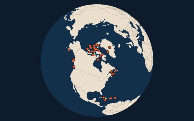
The whole world
More in North America
- 25 largest cities in North America
- Countries of North America
- 25 largest regions in North America
- 25 largest lakes in North America
- 25 longest rivers in North America
- 25 highest peaks in North America
- 25 largest islands in North America
- 14 largest glaciers in North America by area
- Flags of North America
- Cities ranked 26–50 in North America
Other continents
- 25 largest islands in Africa
- 25 largest islands in Asia
- Islands in Asia among the world’s 100 largest
- 25 largest islands in Europe
- Islands in Europe among the world’s 100 largest
- 25 largest islands in South America
The whole world
How the figures are measured
Land area in km²: the Largest Islands set’s figure for its islands, else Wikidata’s (P2046) where it fits the outline, else the area of the outline. Every island Natural Earth draws at 1:10m that Wikidata names, of 5 km² or more (smaller ones when well known), and every island of the Largest Islands set. Countries are those the island’s land lies in, from the outlines. Islands in Antarctica are left out unless the quiz includes Antarctica. Places are by geography: what lies in a dependency counts for its own region (Puerto Rico’s islands are the Caribbean’s, Réunion’s Africa’s), and Hawaii is in Polynesia. Ranked in the world first: the 100 largest islands of the world, and of those the ones in North America.