GeotchaA geography quiz on a real globe
Regions formerly held by Austria
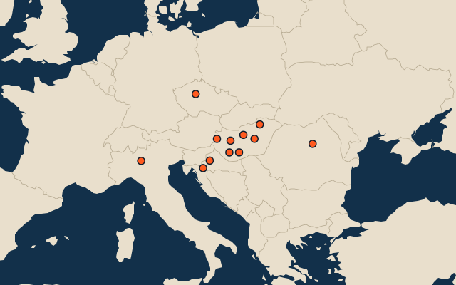
12 regions, each one drawn on a satellite globe. Name it when it lights up, find it when you are given its name, tell its flag from three others, or type every one you can remember in Name all.
Free to play, with no account needed. What you miss comes back for review until it sticks.
The regions
- 1Lombardy23,863 km²
- 2Harghita6,639 km²
- 3Karlovac3,626 km²
- 4Zagreb640 km²
- 5Budapest525 km²
- 6Prague496 km²
- 7Miskolc237 km²
- 8Szolnok187 km²
- 9Veszprém127 km²
- 10Kaposvár114 km²
- 11Szombathely98 km²
- 12Szekszárd96 km²
Area in km²: Wikidata’s figure (P2046, the whole or the land area, whichever matches the outline) where it is within a factor of two of the outline’s area; the official area where the national statistics office gives one (countries whose divisions changed since Natural Earth); else the area measured on the outline. Each item names its source. Austria (with Austria-Hungary and the Habsburg monarchy): places once under its rule and not now, from Wikidata’s dated country statements and colonial-empire membership, and the CIA World Factbook’s independence dates; military occupations of a few years are left out. A region of a country held as a whole is left out: the country is the answer there. Sources: Natural Earth 1:10m admin-1 (public domain), OpenStreetMap (ODbL), Wikidata (CC0), national statistics offices.
On the map
More in Austria
Similar quizzes
- Regions formerly held by Russia
- Regions formerly held by the Ottoman Empire
- Regions formerly held by Hungary
- Regions formerly held by Germany
- Regions formerly held by Poland
- Regions formerly held by the Holy Roman Empire
- Regions formerly held by Denmark
- Soviet republics in 1980
- States of the German Empire in 1900
- US states and territories in 1850
- US states