GeotchaA geography quiz on a real globe
Counties of Kenya
47 counties, each one drawn on a satellite globe. Name it when it lights up, find it when you are given its name, or type every one you can remember in Name all.
Free to start: a few quizzes a day cost nothing, and Geotcha Plus opens every quiz. What you miss comes back for review until it sticks.
The full list
About this quiz
Marsabit is the largest of the 47 counties in this quiz, at 76,334 km²; Mombasa is the smallest listed, at 288 km². The three largest hold 34% of the combined area of all 47.
What they are known for
- Marsabit: Forest-clad volcanic mountain rising from desert, with crater lakes, the Chalbi Desert and Rendille and Gabra herders.
- Turkana: Hot desert shore of a jade-coloured lake, with Koobi Fora hominin fossils and Nile crocodiles.
- Wajir: Dry northeastern plain of Somali camel herders, deep wells and low acacia scrub.
- Garissa: Hot, dry northeast of Somali herders, camel trade and the Dadaab refugee camps.
- Tana River: Hot semi-arid land of the Pokomo and Orma along the country's longest watercourse, with delta wetlands and hippos.
- Kitui: Dry eastern Kamba country of granite hills, mango farms and the Mwingi reserve.
- Mandera: Remote northeastern corner meeting Somalia and Ethiopia, arid pastoral land.
- Isiolo: Arid crossroads to the north, camel trade and Buffalo Springs reserve along the Ewaso Nyiro.
The counties
- 1Marsabit76,334 km²
- 2Turkana70,237 km²
- 3Wajir56,944 km²
- 4Garissa43,797 km²
- 5Tana River39,362 km²
- 6Kitui30,580 km²
- 7Mandera25,935 km²
- 8Isiolo25,506 km²
- 9Kajiado22,011 km²
- 10Samburu21,118 km²
- 11Narok17,949 km²
- 12Taita–Taveta17,171 km²
- 13Kilifi13,127 km²
- 14Baringo10,936 km²
- 15Laikipia9,595 km²
- 16West Pokot9,346 km²
- 17Makueni8,227 km²
- 18Kwale7,974 km²
- 19Nakuru7,483 km²
- 20Meru7,033 km²
- 21Lamu6,345 km²
- 22Machakos6,072 km²
- 23Homa Bay4,715 km²
- 24Siaya3,542 km²
- 25Uasin Gishu3,415 km²
- 26Nyeri3,357 km²
- 27Nyandarua3,302 km²
- 28Migori3,158 km²
- 29Bungoma3,035 km²
- 30Kakamega3,023 km²
- 31Elgeyo-Marakwet3,016 km²
- 32Nandi2,852 km²
- 33Embu2,829 km²
- 34Kisumu2,682 km²
- 35Tharaka-Nithi2,592 km²
- 36Kericho2,588 km²
- 37Kiambu2,545 km²
- 38Murang'a2,539 km²
- 39Trans-Nzoia2,502 km²
- 40Bomet2,380 km²
- 41Busia1,813 km²
- 42Kirinyaga1,482 km²
- 43Kisii1,327 km²
- 44Nyamira902 km²
- 45Nairobi697 km²
- 46Vihiga565 km²
- 47Mombasa288 km²
On the map
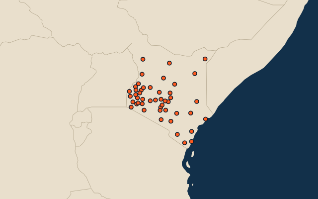
All of Africa
More in Kenya
- 25 largest cities in Kenya
- 10 most populous counties of Kenya
- 10 largest lakes in Kenya
- 7 longest rivers in Kenya
- 22 highest peaks in Kenya
- 9 largest islands in Kenya
- 8 best known World Heritage Sites in Kenya
- 10 largest cities in Kenya
- Cities ranked 26–50 in Kenya
- County capitals of Kenya
Other countries of Africa
- States and the capital territory of Nigeria
- 10 most populous states and the capital territory of Nigeria
- Districts of Côte d'Ivoire
- 10 most populous districts of Côte d'Ivoire
- Provinces of South Africa
- 9 most populous provinces of South Africa
- Provinces of Algeria
- 10 most populous provinces of Algeria
How the figures are measured
The 47 counties of Kenya.