GeotchaA geography quiz on a real globe
Provinces of Algeria
69 provinces, each one drawn on a satellite globe. Name it when it lights up, find it when you are given its name, or type every one you can remember in Name all.
Free to start: a few quizzes a day cost nothing, and Geotcha Plus opens every quiz. What you miss comes back for review until it sticks.
The full list
About this quiz
Tamanrasset is the largest of the 69 provinces in this quiz, at 366,673 km²; Algiers is the smallest listed, at 770 km². Tamanrasset's area is 1.6 times Adrar's (232,584 km²). The three largest hold 35% of the combined area of all 69.
What they are known for
- Tamanrasset: Hoggar mountains, Tuareg capital and Assekrem hermitage of Charles de Foucauld.
- Adrar: Red-sand Saharan oases in the southwest, watered by ancient foggara tunnels, with a hot desert plain.
- Illizi: Libyan border, In Amenas gas field and the eastern Tassili n'Ajjer plateau.
- Tindouf: Far southwestern corner near Mauritania and Western Sahara, home to Sahrawi refugee camps and iron ore.
- In Salah: Red-clay oasis town on the road to the Hoggar, among the hottest places on Earth in summer.
- Bordj Badji Mokhtar: Far southwestern outpost on the Mali border in Tanezrouft, the land of thirst.
- Ouargla: Saharan oil and gas fields of Hassi Messaoud, a palm oasis city and the Grand Erg Oriental dunes.
- Béni Abbès: Palm oasis in the Saoura valley beside towering Grand Erg Occidental dunes, nicknamed the Saharan pearl.
The provinces
- 1Tamanrasset366,673 km²
- 2Adrar232,584 km²
- 3Illizi206,110 km²
- 4Tindouf161,907 km²
- 5In Salah138,327 km²
- 6Bordj Badji Mokhtar136,267 km²
- 7Ouargla135,477 km²
- 8Béni Abbès111,313 km²
- 9In Guezzam98,386 km²
- 10Djanet88,401 km²
- 11Timimoun65,525 km²
- 12El Menia63,347 km²
- 13Béchar49,640 km²
- 14El Abiodh Sidi Cheikh41,392 km²
- 15El Oued35,672 km²
- 16El Bayadh30,368 km²
- 17Naâma29,770 km²
- 18Ghardaïa21,191 km²
- 19Laghouat20,986 km²
- 20Touggourt18,829 km²
- 21Tiaret17,235 km²
- 22Messaad15,142 km²
- 23Ouled Djellal11,303 km²
- 24Djelfa10,893 km²
- 25Bou Saâda10,795 km²
- 26Khenchela9,577 km²
- 27Sidi Bel Abbès9,382 km²
- 28Tébessa9,056 km²
- 29Biskra8,798 km²
- 30Batna8,522 km²
- 31El M'Ghair8,095 km²
- 32M'Sila7,127 km²
- 33Saïda6,769 km²
- 34Sétif6,661 km²
- 35Aflou6,589 km²
- 36Aïn Oussera6,329 km²
- 37Oum El Bouaghi6,256 km²
- 38Tlemcen6,049 km²
- 39Mascara5,676 km²
- 40Relizane4,874 km²
- 41Ksar El Boukhari4,717 km²
- 42Aïn Defla4,541 km²
- 43Bouïra4,474 km²
- 44Souk Ahras4,233 km²
- 45Bir El Ater4,173 km²
- 46Skikda4,135 km²
- 47Chlef4,065 km²
- 48Médéa3,993 km²
- 49Bordj Bou Arréridj3,936 km²
- 50Guelma3,681 km²
- 51Barika3,604 km²
- 52Mila3,500 km²
- 53Béjaïa3,229 km²
- 54Tissemsilt3,205 km²
- 55El Aricha3,004 km²
- 56Tizi Ouzou2,965 km²
- 57Ksar Chellala2,877 km²
- 58El Taref2,871 km²
- 59Jijel2,397 km²
- 60Aïn Témouchent2,381 km²
and 9 more, all in the quiz.
On the map
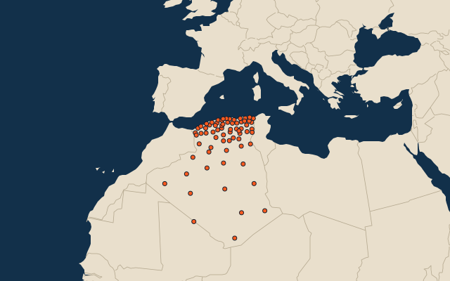
All of Africa
More in Algeria
- 25 largest cities in Algeria
- 10 most populous provinces of Algeria
- 11 longest rivers in Algeria
- 10 highest peaks in Algeria
- 7 best known World Heritage Sites in Algeria
- 10 largest cities in Algeria
- Cities ranked 26–50 in Algeria
- Provincial capitals of Algeria
- Cities over 100,000 in Algeria
Other countries of Africa
- States and the capital territory of Nigeria
- 10 most populous states and the capital territory of Nigeria
- Districts of Côte d'Ivoire
- 10 most populous districts of Côte d'Ivoire
- Provinces of South Africa
- 9 most populous provinces of South Africa
- Governorates of Egypt
- 10 most populous governorates of Egypt
How the figures are measured
The 69 provinces of Algeria.