GeotchaA geography quiz on a real globe
50 largest islands in the Solomon Islands (archipelago)
50 islands, each one drawn on a satellite globe. Name it when it lights up, find it when you are given its name, or type every one you can remember in Name all.
Free to start: a few quizzes a day cost nothing, and Geotcha Plus opens every quiz. What you miss comes back for review until it sticks.
The full list
About this quiz
Bougainville Island is the largest of the 50 islands in this quiz, at 9,318 km²; Owariki is the smallest listed, at 6 km². Bougainville Island's area is 1.8 times Guadalcanal's (5,302 km²). The three largest hold 50% of the combined area of all 50. The Solomon Islands has 47 of the 50, in a list that spans two countries.
What they are known for
- Bougainville Island: Voted 98 percent for independence in 2019; its Panguna copper mine sparked a civil war.
The islands
- 1Bougainville Island Papua New Guinea9,318 km²
- 2Guadalcanal Solomon Islands5,302 km²
- 3Malaita Solomon Islands4,307 km²
- 4Santa Isabel Solomon Islands3,665 km²
- 5Makira Solomon Islands3,190 km²
- 6Choiseul Island Solomon Islands2,971 km²
- 7New Georgia Solomon Islands2,037 km²
- 8Kolombangara Solomon Islands688 km²
- 9Buka Island Papua New Guinea682 km²
- 10Rennell Island Solomon Islands660 km²
- 11Vella Lavella Solomon Islands629 km²
- 12Vangunu Solomon Islands509 km²
- 13Nendö Solomon Islands506 km²
- 14South Malaita Island Solomon Islands481 km²
- 15Rendova Island Solomon Islands411 km²
- 16Nukumanu Islands Papua New Guinea248 km²
- 17Shortland Island Solomon Islands212 km²
- 18San Jorge Island Solomon Islands184 km²
- 19Ranongga Solomon Islands142 km²
- 20Pavuvu Solomon Islands120 km²
- 21Tetepare Island Solomon Islands118 km²
- 22Wagina Island Solomon Islands110 km²
- 23Barora Ite Island Solomon Islands98 km²
- 24Mono Island Solomon Islands96 km²
- 25Nggatokae Island Solomon Islands93 km²
- 26Fauro Island Solomon Islands75 km²
- 27Utupua Solomon Islands69 km²
- 28Ulawa Island Solomon Islands66 km²
- 29Vonavona Solomon Islands57 km²
- 30Rob Roy Island Solomon Islands51 km²
- 31Mbanika Solomon Islands44 km²
- 32Uki Ni Masi Solomon Islands44 km²
- 33Ghaghe Solomon Islands41 km²
- 34Ghizo Island Solomon Islands35 km²
- 35Ovau Island Solomon Islands35 km²
- 36Malo (Solomon Islands) Solomon Islands31 km²
- 37Savo Island Solomon Islands31 km²
- 38Mbokonumbeta Island Solomon Islands25 km²
- 39Lomlom Solomon Islands22 km²
- 40Langa Langa Lagoon Solomon Islands21 km²
- 41Bellona Island Solomon Islands17 km²
- 42Vanikoro Solomon Islands17 km²
- 43Owaraha Solomon Islands16 km²
- 44Mbava Solomon Islands13 km²
- 45Simbo Solomon Islands13 km²
- 46Malaupaina Solomon Islands9 km²
- 47Stirling Island Solomon Islands9 km²
- 48Taumako Solomon Islands8 km²
- 49Tinakula Solomon Islands8 km²
- 50Owariki Solomon Islands6 km²
On the map
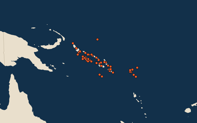
More in Solomon Islands (archipelago)
Similar quizzes
- 50 largest islands in the Pacific Islands
- 50 largest islands in the Malay Archipelago
- 50 largest islands in Melanesia
- 50 largest islands in the British Isles
- 50 largest islands in the Sunda Islands
- 50 largest islands in Polynesia
- 50 largest islands in the Arctic Archipelago
- 50 largest islands in the Greater Sunda Islands
The whole world
How the figures are measured
Land area in km²: the Largest Islands set’s figure for its islands, else Wikidata’s (P2046) where it fits the outline, else the area of the outline. Every island Natural Earth draws at 1:10m that Wikidata names, of 5 km² or more (smaller ones when well known), and every island of the Largest Islands set. Countries are those the island’s land lies in, from the outlines. The Solomon Islands (archipelago): the 64 islands of the island group, its smaller groups included (the islands pool's islands only).