GeotchaA geography quiz on a real globe
50 largest islands in the British Isles
50 islands, each one drawn on a satellite globe. Name it when it lights up, find it when you are given its name, or type every one you can remember in Name all.
Free to start: a few quizzes a day cost nothing, and Geotcha Plus opens every quiz. What you miss comes back for review until it sticks.
The full list
About this quiz
Great Britain is the largest of the 50 islands in this quiz, at 209,331 km²; Garmna is the smallest listed, at 23 km². Great Britain's area is 2.5 times Ireland's (84,421 km²). The three largest hold 97% of the combined area of all 50. The United Kingdom has 41 of the 50, in a list that spans five countries.
What they are known for
- Great Britain: Holds England, Scotland and Wales, with London on the Thames and Edinburgh far to the north.
- Ireland: The Emerald Isle, shared by a republic with Dublin and a United Kingdom region with Belfast.
The islands
- 1Great Britain United Kingdom209,331 km²
- 2Ireland84,421 km²
- 3Lewis and Harris United Kingdom2,086 km²
- 4Isle of Skye United Kingdom1,656 km²
- 5Mainland United Kingdom969 km²
- 6Isle of Mull United Kingdom886 km²
- 7Anglesey United Kingdom749 km²
- 8Islay United Kingdom620 km²
- 9Isle of Man573 km²
- 10Mainland (Scotland) United Kingdom540 km²
- 11Isle of Arran United Kingdom432 km²
- 12Isle of Wight United Kingdom380 km²
- 13Jura United Kingdom367 km²
- 14South Uist United Kingdom320 km²
- 15North Uist United Kingdom303 km²
- 16Yell United Kingdom212 km²
- 17Achill Island Ireland148 km²
- 18Hoy United Kingdom143 km²
- 19Isle of Bute United Kingdom122 km²
- 20Unst United Kingdom121 km²
- 21Jersey118 km²
- 22Rùm United Kingdom104 km²
- 23Isle of Sheppey United Kingdom93 km²
- 24Benbecula United Kingdom82 km²
- 25Tiree United Kingdom78 km²
- 26Coll United Kingdom77 km²
- 27Isle of Raasay United Kingdom64 km²
- 28Guernsey63 km²
- 29Barra United Kingdom59 km²
- 30Sanday United Kingdom50 km²
- 31South Ronaldsay United Kingdom50 km²
- 32Rousay United Kingdom49 km²
- 33Westray United Kingdom47 km²
- 34Colonsay United Kingdom41 km²
- 35Fetlar United Kingdom41 km²
- 36Holy Island United Kingdom39 km²
- 37Stronsay United Kingdom33 km²
- 38Eday United Kingdom32 km²
- 39Eigg United Kingdom31 km²
- 40Inis Mór Ireland31 km²
- 41Hayling Island United Kingdom30 km²
- 42Foulness Island United Kingdom29 km²
- 43Shapinsay United Kingdom29 km²
- 44Bressay United Kingdom28 km²
- 45Valentia Island Ireland26 km²
- 46Great Island Ireland25 km²
- 47Scalpay United Kingdom25 km²
- 48Lismore United Kingdom24 km²
- 49Portsea Island United Kingdom24 km²
- 50Garmna Ireland23 km²
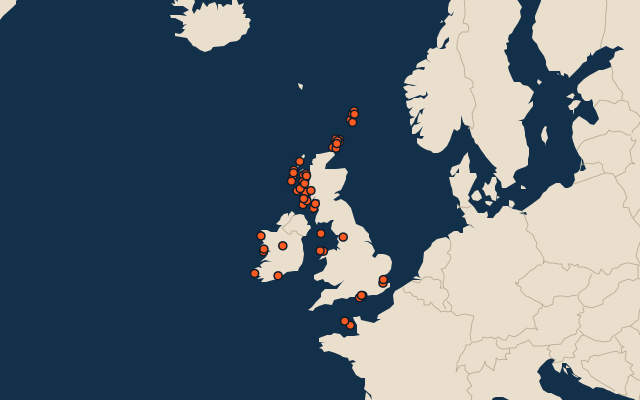
On the map
More in British Isles
Similar quizzes
- 50 largest islands in the Pacific Islands
- 50 largest islands in the Malay Archipelago
- 50 largest islands in Melanesia
- 50 largest islands in the Sunda Islands
- 50 largest islands in Polynesia
- 50 largest islands in the Arctic Archipelago
- 50 largest islands in the Greater Sunda Islands
- 50 largest islands in the West Indies
The whole world
How the figures are measured
Land area in km²: the Largest Islands set’s figure for its islands, else Wikidata’s (P2046) where it fits the outline, else the area of the outline. Every island Natural Earth draws at 1:10m that Wikidata names, of 5 km² or more (smaller ones when well known), and every island of the Largest Islands set. Countries are those the island’s land lies in, from the outlines. The British Isles: the 272 islands of the island group, its smaller groups included (the islands pool's islands only).