GeotchaA geography quiz on a real globe
50 largest islands in the Greater Sunda Islands
50 islands, each one drawn on a satellite globe. Name it when it lights up, find it when you are given its name, or type every one you can remember in Name all.
Free to start: a few quizzes a day cost nothing, and Geotcha Plus opens every quiz. What you miss comes back for review until it sticks.
The full list
About this quiz
Borneo is the largest of the 50 islands in this quiz, at 748,168 km²; Nusakambangan Island is the smallest listed, at 121 km². Borneo's area is 1.6 times Sumatra's (473,481 km²). The three largest hold 88% of the combined area of all 50. Indonesia has 47 of the 50, in a list that spans two countries.
What they are known for
- Borneo: Shared by Indonesia, Malaysia and Brunei; rainforest home of orangutans and pygmy elephants.
- Sumatra: Tigers, rhinos, elephants and orangutans all live here; Banda Aceh at its tip was devastated by the 2004 tsunami.
- Sulawesi: Four long peninsulas give it a spidery shape; the Toraja highlands hold elaborate cliff graves.
- Java: Home to over half of Indonesia's people, with Jakarta, Borobudur and a chain of volcanoes.
- Bangka: One of the world's leading sources of tin for centuries.
The islands
- 1Borneo Indonesia748,168 km²
- 2Sumatra Indonesia473,481 km²
- 3Sulawesi Indonesia174,600 km²
- 4Java Indonesia128,297 km²
- 5Bangka Indonesia11,413 km²
- 6Nias Indonesia5,125 km²
- 7Belitung Indonesia4,478 km²
- 8Madura Indonesia4,429 km²
- 9Buton Indonesia4,408 km²
- 10Muna Island Indonesia2,889 km²
- 11Peling Island Indonesia2,346 km²
- 12Laut Island Indonesia2,057 km²
- 13Simeulue Indonesia1,754 km²
- 14Tebing Tinggi Island Indonesia1,598 km²
- 15Rupat Indonesia1,490 km²
- 16Bintan Island Indonesia1,173 km²
- 17Padang Island Indonesia1,109 km²
- 18Bengkalis Island Indonesia929 km²
- 19Rangsang Indonesia908 km²
- 20Lingga Island Indonesia889 km²
- 21Sempu Indonesia877 km²
- 22Kabaena Indonesia872 km²
- 23Karakelang Indonesia846 km²
- 24Singkep Indonesia757 km²
- 25Wawonii Island Indonesia715 km²
- 26Selayar Island Indonesia666 km²
- 27Samosir Indonesia630 km²
- 28Pagai Utara Island Indonesia622 km²
- 29Sangihe Island Indonesia552 km²
- 30Bruit Island Malaysia530 km²
- 31Sebatik Island Indonesia452 km²
- 32Banggi Island Malaysia441 km²
- 33Batam Island Indonesia415 km²
- 34Enggano Island Indonesia397 km²
- 35Kundur Island Indonesia315 km²
- 36Penyalai Island Indonesia304 km²
- 37Banggai Island Indonesia268 km²
- 38Batu Daka Island Indonesia266 km²
- 39Tarakan Island Indonesia248 km²
- 40Togean Island Indonesia237 km²
- 41Nunukan Island Indonesia235 km²
- 42Sebuku Island (South Kalimantan) Indonesia214 km²
- 43Lepar Island Indonesia211 km²
- 44Bawean Indonesia196 km²
- 45Rempang Island Indonesia154 km²
- 46Jambongan Island Malaysia144 km²
- 47Sapudi Island Indonesia130 km²
- 48Karimun Island Indonesia126 km²
- 49Panaitan Indonesia122 km²
- 50Nusakambangan Island Indonesia121 km²
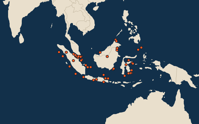
On the map
More in Greater Sunda Islands
Similar quizzes
- 50 largest islands in the Pacific Islands
- 50 largest islands in the Malay Archipelago
- 50 largest islands in Melanesia
- 50 largest islands in the British Isles
- 50 largest islands in the Sunda Islands
- 50 largest islands in Polynesia
- 50 largest islands in the Arctic Archipelago
- 50 largest islands in the West Indies
The whole world
How the figures are measured
Land area in km²: the Largest Islands set’s figure for its islands, else Wikidata’s (P2046) where it fits the outline, else the area of the outline. Every island Natural Earth draws at 1:10m that Wikidata names, of 5 km² or more (smaller ones when well known), and every island of the Largest Islands set. Countries are those the island’s land lies in, from the outlines. The Greater Sunda Islands: the 217 islands of the island group, its smaller groups included (the islands pool's islands only).