GeotchaA geography quiz on a real globe
50 largest islands in the Ryukyu Islands
50 islands, each one drawn on a satellite globe. Name it when it lights up, find it when you are given its name, or type every one you can remember in Name all.
Free to start: a few quizzes a day cost nothing, and Geotcha Plus opens every quiz. What you miss comes back for review until it sticks.
The full list
About this quiz
Okinawa is the largest of the 50 islands in this quiz, at 1,208 km²; Uotsuri Island is the smallest listed, at 3 km². Okinawa's area is 1.7 times Amami Ōshima's (712 km²). The three largest hold 53% of the combined area of all 50. Japan has 49 of the 50, in a list that spans two countries.
The islands
- 1Okinawa Japan1,208 km²
- 2Amami Ōshima Japan712 km²
- 3Yakushima Japan504 km²
- 4Tanegashima Japan444 km²
- 5Iriomote Island Japan289 km²
- 6Tokunoshima Japan248 km²
- 7Ishigaki Island Japan222 km²
- 8Miyako Island Japan159 km²
- 9Okinoerabujima Japan94 km²
- 10Kakeromajima Japan77 km²
- 11Kume Island Japan60 km²
- 12Kikai Island Japan57 km²
- 13Kuchinoerabu Island Japan38 km²
- 14Nakanoshima Japan34 km²
- 15Minamidaitō Island Japan31 km²
- 16Irabu Island Japan29 km²
- 17Yonaguni Japan29 km²
- 18Suwanosejima Japan28 km²
- 19Iejima Japan23 km²
- 20Iheya Island Japan21 km²
- 21Yoronjima Japan21 km²
- 22Tarama Island Japan20 km²
- 23Kuroshima (Kagoshima) Japan15 km²
- 24Tokashiki Island Japan15 km²
- 25Izena Island Japan14 km²
- 26Hateruma Japan13 km²
- 27Kuchinoshima Japan13 km²
- 28Uke Island Japan13 km²
- 29Iōjima Japan12 km²
- 30Kitadaitō Island Japan12 km²
- 31Miyagi Island Japan11 km²
- 32Kuroshima Japan10 km²
- 33Yoroshima Japan9 km²
- 34Aguni Island Japan8 km²
- 35Kohama Island Japan8 km²
- 36Mageshima Japan8 km²
- 37Akusekijima Japan7 km²
- 38Takarajima Japan7 km²
- 39Zamami Island Japan7 km²
- 40Edateku Island Japan6 km²
- 41Taketomi Island Japan5 km²
- 42Aka Island Japan4 km²
- 43Gajajima Japan4 km²
- 44Takeshima Japan4 km²
- 45Aragusuku Islands Japan3 km²
- 46Ikema Island Japan3 km²
- 47Iōtorishima Japan3 km²
- 48Kurima Island Japan3 km²
- 49Sesoko Island Japan3 km²
- 50Uotsuri Island China3 km²
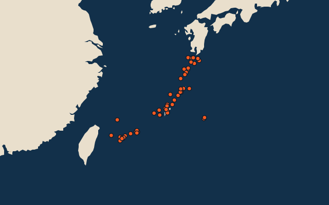
On the map
More in Ryukyu Islands
Similar quizzes
- 50 largest islands in the Pacific Islands
- 50 largest islands in the Malay Archipelago
- 50 largest islands in Melanesia
- 50 largest islands in the British Isles
- 50 largest islands in the Sunda Islands
- 50 largest islands in Polynesia
- 50 largest islands in the Arctic Archipelago
- 50 largest islands in the Greater Sunda Islands
The whole world
How the figures are measured
Land area in km²: the Largest Islands set’s figure for its islands, else Wikidata’s (P2046) where it fits the outline, else the area of the outline. Every island Natural Earth draws at 1:10m that Wikidata names, of 5 km² or more (smaller ones when well known), and every island of the Largest Islands set. Countries are those the island’s land lies in, from the outlines. The Ryukyu Islands: the 64 islands of the island group, its smaller groups included (the islands pool's islands only).