GeotchaA geography quiz on a real globe
50 largest islands in the Greater Antilles
50 islands, each one drawn on a satellite globe. Name it when it lights up, find it when you are given its name, or type every one you can remember in Name all.
Free to start: a few quizzes a day cost nothing, and Geotcha Plus opens every quiz. What you miss comes back for review until it sticks.
The full list
About this quiz
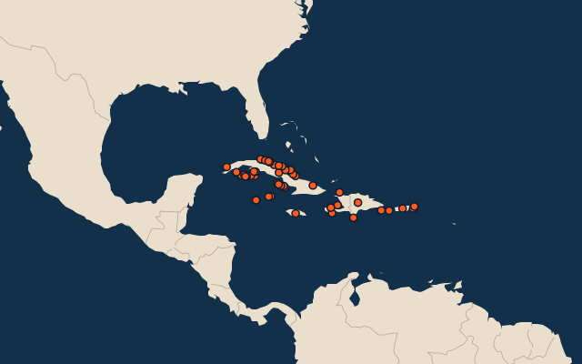
Cuba is the largest of the 50 islands in this quiz, at 105,806 km²; Cayo Hicacal is the smallest listed, at 10 km². The three largest hold 93% of the combined area of all 50. Cuba has 35 of the 50, in a list that spans six countries.
What they are known for
- Cuba: Caribbean island known for cigars, vintage American cars and its capital Havana.
- Hispaniola: Shared by Haiti and the Dominican Republic; Columbus founded the first Spanish settlement in the Americas here.
- Jamaica: Birthplace of reggae and Bob Marley; its name comes from the Taíno for land of wood and water.
- Puerto Rico: US territory in the Caribbean whose residents are US citizens but cannot vote for president.
The islands
- 1Cuba105,806 km²
- 2Hispaniola Haiti76,420 km²
- 3Jamaica11,190 km²
- 4Puerto Rico United States8,868 km²
- 5Isla de la Juventud Cuba2,419 km²
- 6Cayo Romano Cuba777 km²
- 7Gonâve Island Haiti743 km²
- 8Cayo Coco Cuba370 km²
- 9Cayo Sabinal Cuba335 km²
- 10Grand Cayman United Kingdom197 km²
- 11Tortuga Haiti180 km²
- 12Vieques United States136 km²
- 13Saona Island Dominican Republic110 km²
- 14Cayo Guajaba Cuba107 km²
- 15Cayo Fragoso Cuba101 km²
- 16Isla de Mona United States57 km²
- 17Île à Vache Haiti52 km²
- 18Cayo Grande (Cuba) Cuba46 km²
- 19Cayemites Haiti45 km²
- 20Cayo Saetia Cuba42 km²
- 21Cayo Cabeza del Este Cuba39 km²
- 22Cayman Brac United Kingdom38 km²
- 23Cayo Largo del Sur Cuba38 km²
- 24Ernst Thälmann Island Cuba38 km²
- 25Cayo Cantiles Cuba31 km²
- 26Little Cayman United Kingdom29 km²
- 27Beata Island Dominican Republic27 km²
- 28Cayo Piedra del Obispo Cuba27 km²
- 29Culebra United States27 km²
- 30Cayo Cruz Cuba26 km²
- 31Cayo de Buenavista Cuba24 km²
- 32Cayo San Juan Cuba24 km²
- 33Cayo Cotorro Cuba23 km²
- 34Cayo Ranas Cuba23 km²
- 35Cayo Iguana Cuba22 km²
- 36Cayo Judas Cuba19 km²
- 37Cayo Llanes Cuba19 km²
- 38Cayo Piedra Chica Cuba19 km²
- 39Cayo Caballones Cuba17 km²
- 40Cayo del Rosario Cuba17 km²
- 41Cayo del Perro Cuba16 km²
- 42Cayo Guillermo Cuba15 km²
- 43Cayo Campos Cuba14 km²
- 44Cayo Galindo Cuba14 km²
- 45Cayo Matías Cuba14 km²
- 46Cayo Santa María Cuba13 km²
- 47Cayo Maravillas Cuba12 km²
- 48Cayo Blanquizal Cuba11 km²
- 49Cayo Diego Pérez Cuba10 km²
- 50Cayo Hicacal Cuba10 km²
On the map
More in Greater Antilles
Similar quizzes
- 50 largest islands in the Pacific Islands
- 50 largest islands in the Malay Archipelago
- 50 largest islands in Melanesia
- 50 largest islands in the British Isles
- 50 largest islands in the Sunda Islands
- 50 largest islands in Polynesia
- 50 largest islands in the Arctic Archipelago
- 50 largest islands in the Greater Sunda Islands
The whole world
How the figures are measured
Land area in km²: the Largest Islands set’s figure for its islands, else Wikidata’s (P2046) where it fits the outline, else the area of the outline. Every island Natural Earth draws at 1:10m that Wikidata names, of 5 km² or more (smaller ones when well known), and every island of the Largest Islands set. Countries are those the island’s land lies in, from the outlines. The Greater Antilles: the 61 islands of the island group, its smaller groups included (the islands pool's islands only).