GeotchaA geography quiz on a real globe
3 largest lakes on each continent
18 lakes, each one drawn on a satellite globe. Name it when it lights up, find it when you are given its name, or type every one you can remember in Name all.
Free to play, with no account needed. What you miss comes back for review until it sticks.
The lakes
- 1Caspian Sea386,400 km²
- 2Lake Superior82,350 km²
- 3Lake Victoria68,100 km²
- 4Lake Huron59,600 km²
- 5Lake Michigan57,750 km²
- 6Lake Tanganyika32,900 km²
- 7Lake Baikal31,722 km²
- 8Lake Malawi29,600 km²
- 9Lake Balkhash18,200 km²
- 10Lake Ladoga17,700 km²
- 11Lake Onega9,800 km²
- 12Lake Titicaca8,372 km²
- 13Lake Eyre North8,144 km²
- 14Mar Chiquita5,770 km²
- 15Lake Torrens5,700 km²
- 16Vänern5,650 km²
- 17Lake Mackay4,737 km²
- 18Lagoa Mirim3,994 km²
Surface area in km²: the Largest Lakes set’s figure for its lakes, else Wikidata’s (P2046) where it fits the outline, else the area of the outline. Seasonal salt pans keep their recorded figure; their area varies. Every named lake Natural Earth maps at 1:10m (with its supplements for Europe, North America and Australia), and every lake of the Largest Lakes set. The Caspian Sea counts as a lake, as in that set; coastal lagoons (the Vistula Lagoon, the Black Sea limans) do not. Countries are those on its shores, from the outlines. Natural lakes only: reservoirs (artificial lakes behind a dam, as Natural Earth or Wikidata mark them) are left out. Lakes in Antarctica are left out unless the quiz includes Antarctica. One per group: the 3 largest lakes of each continent by this measure, then ranked together.
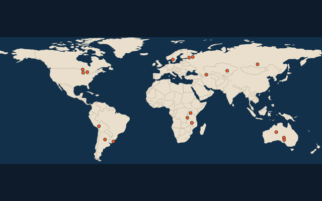
On the map
More of the world
- Largest city of each 10° band of latitude
- Largest country on each continent
- Most populous region of each country, top 100
- Highest peak of each country
- Largest lake on each continent
- Longest river on each continent
- Largest island on each continent
- Largest city of each 30° band of longitude
- Most populous country on each continent
- Highest peak on each continent