GeotchaA geography quiz on a real globe
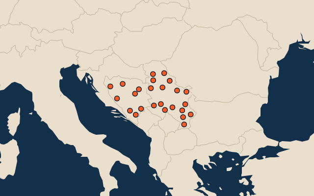
25 largest regions with Serbian as an official language
25 regions, each one drawn on a satellite globe. Name it when it lights up, find it when you are given its name, or type every one you can remember in Name all.
Free to play, with no account needed. What you miss comes back for review until it sticks.
The regions
- 1Banja Luka8,869 km²
- 2Zlatibor6,140 km²
- 3Livno5,251 km²
- 4Herzegovina-Neretva Canton4,401 km²
- 5South Banat4,245 km²
- 6Una-Sana Canton4,125 km²
- 7South Bačka4,016 km²
- 8Raška3,918 km²
- 9Braničevo3,865 km²
- 10Zaječar3,623 km²
- 11Pčinja3,520 km²
- 12Bor3,507 km²
- 13Srem3,486 km²
- 14Zenica-Doboj Canton3,415 km²
- 15Mačva3,268 km²
- 16Central Banat3,256 km²
- 17Belgrade3,224 km²
- 18Trebinje3,192 km²
- 19Moravica3,016 km²
- 20Foča2,779 km²
- 21Jablanica2,769 km²
- 22Pirot2,761 km²
- 23Nišava2,729 km²
- 24Rasina2,667 km²
- 25Tuzla Canton2,649 km²
Area in km²: Wikidata’s figure (P2046, the whole or the land area, whichever matches the outline) where it is within a factor of two of the outline’s area; else the area measured on the outline. Each item names its source. Official languages: official nationally, as the Unicode CLDR territory data and the CIA World Factbook record them; a city or region counts with its own official languages, else those of the region or country it lies in. Sources: Natural Earth 1:10m admin-1 (public domain), OpenStreetMap (ODbL), Wikidata (CC0).
On the map
More in Serbian
Similar quizzes
- 25 largest regions with English as an official language
- 25 largest regions with French as an official language
- 25 largest regions with Spanish as an official language
- 25 largest regions with Arabic as an official language
- 25 largest regions with Portuguese as an official language
- 25 largest regions with German as an official language
- 25 largest regions with Russian as an official language
- 25 largest regions with Chinese as an official language
- 25 largest regions with Italian as an official language
- 25 largest regions with Dutch as an official language
- US states