GeotchaA geography quiz on a real globe
25 largest regions with Albanian as an official language
25 regions, each one drawn on a satellite globe. Name it when it lights up, find it when you are given its name, tell its flag from three others, or type every one you can remember in Name all.
Free to start: a few quizzes a day cost nothing, and Geotcha Plus opens every quiz. What you miss comes back for review until it sticks.
The full list
About this quiz
Korçë is the largest of the 25 regions in this quiz, at 3,711 km²; Durrës is the smallest listed, at 766 km². The three largest hold 25% of the combined area of all 25. They lie in three countries; Albania has the most, with 12.
What they are known for
- Korçë: Pogradec faces Lake Ohrid; Voskopoja preserves painted Orthodox churches in the southeastern highlands.
- Shkodër: Rozafa castle overlooks a large border lake; Theth’s alpine valley lies in the northern mountains.
- Elbasan: A walled old town anchors the Shkumbin valley; the Via Egnatia once crossed this central county.
- Gjirokastër: A stone-built UNESCO town has an imposing castle; the Vjosa flows past Përmet’s hot springs.
- Vlorë: Sarandë, ancient Butrint and the beaches of the Riviera lie along the southern Ionian coast.
- Dibër: Peshkopi has thermal springs; Korab’s high peaks rise along the North Macedonian frontier.
- Kukës: Valbona’s mountain valley and a reservoir on the Drin lie near the borders with Kosovo.
- Nikšić: A brewery, King Nikola’s palace and the artificial lakes of Krupac and Slano mark this inland municipality.
The regions
- 1Korçë Albania3,711 km²
- 2Shkodër Albania3,562 km²
- 3Elbasan Albania3,325 km²
- 4Gjirokastër Albania2,884 km²
- 5Vlorë Albania2,706 km²
- 6Dibër Albania2,586 km²
- 7Kukës Albania2,374 km²
- 8Nikšić Montenegro2,137 km²
- 9Fier Albania1,890 km²
- 10Berat Albania1,798 km²
- 11Tirana Albania1,652 km²
- 12Lezhë Albania1,620 km²
- 13Pljevlja Montenegro1,333 km²
- 14Prilep North Macedonia1,234 km²
- 15Podgorica Montenegro989 km²
- 16Kavadarci North Macedonia980 km²
- 17Bijelo Polje Montenegro920 km²
- 18Kolašin Montenegro899 km²
- 19Cetinje Montenegro895 km²
- 20Makedonski Brod North Macedonia891 km²
- 21Plužine Montenegro847 km²
- 22Čaška North Macedonia818 km²
- 23Kičevo North Macedonia818 km²
- 24Bitola North Macedonia788 km²
- 25Durrës Albania766 km²
On the map
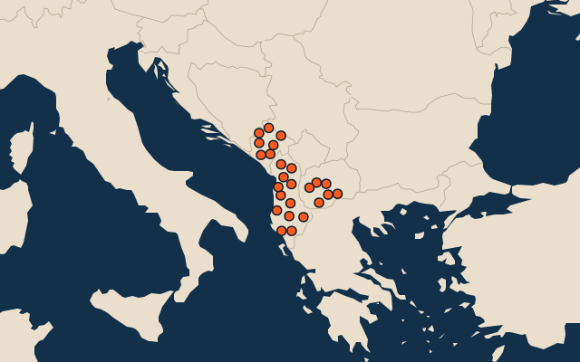
More in Albanian
Similar quizzes
- 25 largest regions with English as an official language
- 25 largest regions with French as an official language
- 25 largest regions with Spanish as an official language
- 25 largest regions with Hindi as an official language
- 25 largest regions with Chinese as an official language
- 25 largest regions with Arabic as an official language
- 13 largest regions with Urdu as an official language
- 25 largest regions with Portuguese as an official language
How the figures are measured
Area in km²: Wikidata’s figure (P2046, the whole or the land area, whichever matches the outline) where it is within a factor of two of the outline’s area; else the area measured on the outline. Each item names its source. Official languages: official nationally, as the Unicode CLDR territory data and the CIA World Factbook record them; a city or region counts with its own official languages, else those of the region or country it lies in.