GeotchaA geography quiz on a real globe
18 largest regions with Tswana as an official language
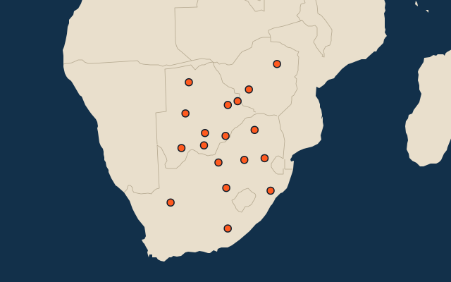
18 regions, each one drawn on a satellite globe. Name it when it lights up, find it when you are given its name, or type every one you can remember in Name all.
Free to start: a few quizzes a day cost nothing, and Geotcha Plus opens every quiz. What you miss comes back for review until it sticks.
The full list
About this quiz
Northern Cape is the largest of the 18 regions in this quiz, at 372,889 km²; Francistown is the smallest listed, at 75 km². Northern Cape's area is 2.2 times Eastern Cape's (168,966 km²). The three largest hold 42% of the combined area of all 18. They lie in three countries; South Africa and Botswana have the most, eight each.
What they are known for
- Northern Cape: Kimberley's Big Hole diamond mine, Kalahari dunes, Namaqualand spring flowers and Augrabies Falls.
- Eastern Cape: Wild Coast of Xhosa villages, Mandela's rural birthplace, Addo elephants and surfing at Jeffreys Bay.
- Central: Serowe’s royal history, the diamond mines of Orapa and the salt pans near Nata lie in this broad district.
- Free State: Maize and gold on the open highveld, with Bloemfontein, golden sandstone cliffs and the Lesotho border.
- Limpopo: Baobabs, Mapungubwe's golden rhino, Venda culture and the northern end of Kruger, by the Zimbabwe border.
- Ghanzi: D’kar’s San cultural centre and cattle ranches occupy sandy Kalahari grasslands near Namibia.
- North-West (Botswana): Maun’s safari gateway opens onto the Okavango Delta, Moremi’s wildlife and the Tsodilo rock paintings.
- Kgalagadi: Tsabong’s camel country and a vast transfrontier park of red dunes lie near South Africa.
The regions
- 1Northern Cape South Africa372,889 km²
- 2Eastern Cape South Africa168,966 km²
- 3Central Botswana146,770 km²
- 4Free State South Africa129,825 km²
- 5Limpopo South Africa125,754 km²
- 6Ghanzi Botswana115,337 km²
- 7North-West (Botswana) Botswana111,800 km²
- 8Kgalagadi Botswana105,156 km²
- 9North West (South Africa) South Africa104,882 km²
- 10KwaZulu-Natal South Africa94,361 km²
- 11Mpumalanga South Africa76,495 km²
- 12Kweneng Botswana37,083 km²
- 13Southern Botswana27,340 km²
- 14Gauteng South Africa18,178 km²
- 15Kgatleng Botswana7,639 km²
- 16Harare Zimbabwe872 km²
- 17Bulawayo Zimbabwe551 km²
- 18Francistown Botswana75 km²
On the map
More in Tswana
Similar quizzes
- 25 largest regions with English as an official language
- 25 largest regions with French as an official language
- 25 largest regions with Spanish as an official language
- 25 largest regions with Hindi as an official language
- 25 largest regions with Chinese as an official language
- 25 largest regions with Arabic as an official language
- 13 largest regions with Urdu as an official language
- 25 largest regions with Portuguese as an official language
How the figures are measured
Area in km²: Wikidata’s figure (P2046, the whole or the land area, whichever matches the outline) where it is within a factor of two of the outline’s area; else the area measured on the outline. Each item names its source. Official languages: official nationally, as the Unicode CLDR territory data and the CIA World Factbook record them; a city or region counts with its own official languages, else those of the region or country it lies in.