GeotchaA geography quiz on a real globe
Provinces of Indonesia
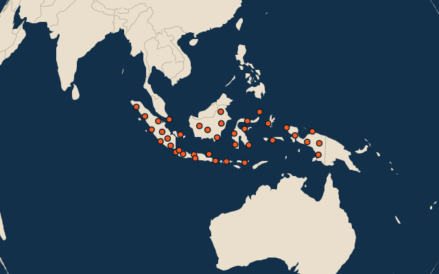
38 provinces, each one drawn on a satellite globe. Name it when it lights up, find it when you are given its name, tell its flag from three others, or type every one you can remember in Name all.
Free to start: a few quizzes a day cost nothing, and Geotcha Plus opens every quiz. What you miss comes back for review until it sticks.
The full list
About this quiz
Central Kalimantan is the largest of the 38 provinces in this quiz, at 154,134 km²; Jakarta is the smallest listed, at 661 km². The three largest hold 23% of the combined area of all 38.
What they are known for
- Central Kalimantan: Tanjung Puting orangutans, klotok boat rides, peat swamps and Dayak villages in Borneo.
- West Kalimantan: Equator monument in its capital on the wide Kapuas River; Dayak longhouses and the Sarawak border.
- East Kalimantan: Mahakam River, Balikpapan oil, Derawan islands and the site of the new capital Nusantara.
- South Papua: Southern lowlands: Wasur wetlands with wallabies, Asmat wood carvers and Indonesia's easternmost city.
- Riau: Oil and palm-oil country on the Malacca Strait coast, with peat forests and the Siak palace.
- South Sumatra: Musi River with the Ampera Bridge, pempek fish cakes and the old Srivijaya empire.
- Papua: Northeast of the island: Lake Sentani, Humboldt Bay, Mamberamo River jungle and the border with PNG.
- North Sumatra: Lake Toba's vast volcanic caldera, Batak culture, Medan's food and orangutans at Bukit Lawang.
The provinces
- 1Central Kalimantan154,134 km²
- 2West Kalimantan147,819 km²
- 3East Kalimantan127,959 km²
- 4South Papua117,864 km²
- 5Riau90,547 km²
- 6South Sumatra87,250 km²
- 7Papua81,338 km²
- 8North Sumatra72,489 km²
- 9North Kalimantan70,725 km²
- 10Central Sulawesi61,429 km²
- 11Central Papua60,507 km²
- 12West Papua60,327 km²
- 13Aceh57,146 km²
- 14Highland Papua53,576 km²
- 15Jambi49,231 km²
- 16East Java48,191 km²
- 17East Nusa Tenggara46,539 km²
- 18Maluku46,313 km²
- 19South Sulawesi45,719 km²
- 20West Sumatra42,317 km²
- 21Southwest Papua39,063 km²
- 22South Kalimantan37,324 km²
- 23West Java37,242 km²
- 24Southeast Sulawesi36,049 km²
- 25Central Java34,594 km²
- 26Lampung33,776 km²
- 27North Maluku31,518 km²
- 28Bengkulu20,210 km²
- 29West Nusa Tenggara19,703 km²
- 30Bangka Belitung Islands16,774 km²
- 31West Sulawesi16,656 km²
- 32North Sulawesi14,558 km²
- 33Gorontalo12,080 km²
- 34Banten9,416 km²
- 35Riau Islands8,136 km²
- 36Bali5,610 km²
- 37Yogyakarta3,193 km²
- 38Jakarta661 km²
On the map
All of Asia
More in Indonesia
- 25 largest cities in Indonesia
- 10 most populous provinces of Indonesia
- 25 longest rivers in Indonesia
- 25 highest peaks in Indonesia
- 25 largest islands in Indonesia
- 10 best known World Heritage Sites in Indonesia
- Flags of the provinces of Indonesia
- 10 largest cities in Indonesia
- Regencies and cities of Indonesia
- Cities ranked 26–50 in Indonesia
In the regions of Indonesia
- Regencies and cities of Aceh
- Regencies and cities of Bali
- Regencies and cities of Bengkulu
- Regencies and cities of Jakarta
- Regencies and cities of Jambi
- Regencies and cities of Central Java
- Regencies and cities of East Java
- Regencies and cities of West Kalimantan
Other countries of Asia
- States of India
- 10 most populous states of India
- Districts of India
- 25 most populous districts of India
- Provinces of China
- 10 most populous provinces of China
- Prefectures of China
- 25 most populous prefectures of China
How the figures are measured
First-level units: the 38 provinces; the 514 regencies and cities are the second level.