GeotchaA geography quiz on a real globe
25 largest lakes in Finland
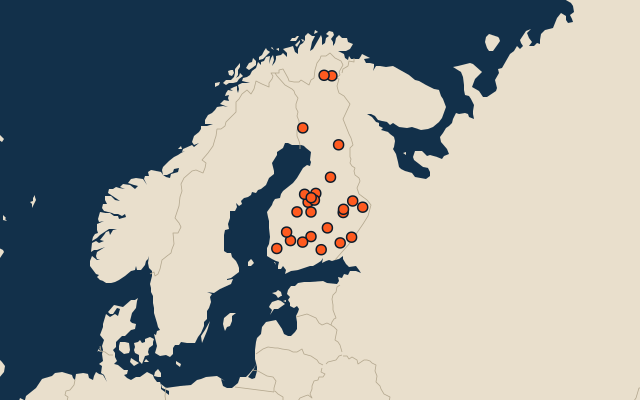
25 lakes, each one drawn on a satellite globe. Name it when it lights up, find it when you are given its name, or type every one you can remember in Name all.
Free to play, with no account needed. What you miss comes back for review until it sticks.
The lakes
- 1Saimaa4,400 km²
- 2Päijänne1,083 km²
- 3Lake Inari1,082 km²
- 4Pielinen894 km²
- 5Oulujärvi887 km²
- 6Juojärvi220 km²
- 7Koitere164 km²
- 8Pyhäjärvi (Satakunta and Southwest Finland)155 km²
- 9Kivijärvi154 km²
- 10Kyyvesi130 km²
- 11Pyhäjärvi122 km²
- 12Pyhäjärvi (North Ostrobothnia)122 km²
- 13Kolima101 km²
- 14Kyrösjärvi96 km²
- 15Lestijärvi65 km²
- 16Rikkavesi63 km²
- 17Pyhäjärvi (Kymenlaakso and Paijat-Hame)62 km²
- 18Pyhäjärvi (Central Finland)59 km²
- 19Simpelejärvi59 km²
- 20Miekojärvi53 km²
- 21Mutusjärvi50 km²
- 22Alvajärvi46 km²
- 23Kostonjärvi44 km²
- 24Kukkia44 km²
- 25Ähtärinjärvi40 km²
Surface area in km²: the Largest Lakes set’s figure for its lakes, else Wikidata’s (P2046) where it fits the outline, else the area of the outline. Seasonal salt pans keep their recorded figure; their area varies. Every named lake Natural Earth maps at 1:10m (with its supplements for Europe, North America and Australia), and every lake of the Largest Lakes set. The Caspian Sea counts as a lake, as in that set; coastal lagoons (the Vistula Lagoon, the Black Sea limans) do not. Countries are those on its shores, from the outlines. Natural lakes only: reservoirs (artificial lakes behind a dam, as Natural Earth or Wikidata mark them) are left out.
On the map
More in Finland
- 7 largest cities in Finland
- Regions of Finland
- 13 longest rivers in Finland
- 25 largest islands in Finland
- Regional capitals of Finland
- 10 most populous regions of Finland