GeotchaA geography quiz on a real globe
10 most populous provinces of Iran
10 provinces, each one drawn on a satellite globe. Name it when it lights up, find it when you are given its name, or type every one you can remember in Name all.
Free to start: a few quizzes a day cost nothing, and Geotcha Plus opens every quiz. What you miss comes back for review until it sticks.
The full list
About this quiz
Tehran is the largest of the 10 provinces in this quiz, at 15.3 M; Sistan and Baluchestan is the smallest listed, at 3.2 M. Tehran's population is about twice Razavi Khorasan's (7.4 M). The three largest hold 49% of the combined population of all 10.
What they are known for
- Tehran: Capital province beneath snowy mountains, with the Milad Tower, a Qajar palace and the Azadi monument.
- Razavi Khorasan: Northeastern province holding Iran's holiest Shia shrine of Imam Reza, the poet Ferdowsi's tomb and saffron fields.
- Isfahan: Heart of Persia, with Naqsh-e Jahan Square, Safavid mosques, the Si-o-se-pol bridge and its blue tiles and sweets.
- Fars: Cradle of ancient Persia, with Persepolis, Pasargadae and Cyrus the Great's tomb, plus poets' tombs and rose water.
- Khuzestan: Southwestern oil province with the Karun river, date palms, Shush and the Elamite ziggurat Chogha Zanbil.
- East Azerbaijan: Northwest Azeri-speaking province with a huge historic covered bazaar, Sahand volcano and Kandovan's cave homes.
- Mazandaran: Caspian shore province of citrus and rice paddies, dense forests and the volcano Mount Damavand's northern flank.
- West Azerbaijan: Northwest province around a huge salt lake, bordering Turkey and Iraq, with Kurdish and Azeri culture and vineyards.
The provinces
- 1Tehran15.3 M
- 2Razavi Khorasan7.4 M
- 3Isfahan5.9 M
- 4Fars5.6 M
- 5Khuzestan5.4 M
- 6East Azerbaijan4.5 M
- 7Mazandaran3.8 M
- 8West Azerbaijan3.8 M
- 9Kerman3.7 M
- 10Sistan and Baluchestan3.2 M
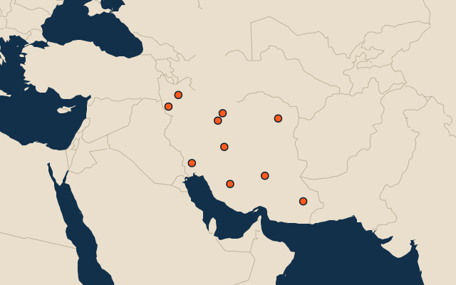
On the map
All of Asia
More in Iran
- 25 largest cities in Iran
- Provinces of Iran
- 25 longest rivers in Iran
- 25 highest peaks in Iran
- 14 largest islands in Iran
- 25 best known World Heritage Sites in Iran
- 10 largest cities in Iran
- Cities ranked 26–50 in Iran
- Provincial capitals of Iran
- Cities over 100,000 in Iran
Other countries of Asia
- States of India
- 10 most populous states of India
- Districts of India
- 25 most populous districts of India
- Provinces of China
- 10 most populous provinces of China
- Prefectures of China
- 25 most populous prefectures of China
How the figures are measured
Population of each region: a 2025 estimate: the latest official figure (a census or an estimate, as each item names it) scaled with the rest of its country’s regions to the World Bank’s 2025 national total, so a country’s regions share one year. Each item names its source and year. Regions without a figure are left out.