GeotchaA geography quiz on a real globe
25 largest lakes in the Middle East
25 lakes, each one drawn on a satellite globe. Name it when it lights up, find it when you are given its name, or type every one you can remember in Name all.
Free to play, with no account needed. What you miss comes back for review until it sticks.
The lakes
- 1Lake Urmia5,200 km²
- 2Lake Van3,755 km²
- 3Lake Tuz2,075 km²
- 4Lake Milh1,501 km²
- 5Lake Hammar1,300 km²
- 6Lake Beyşehir650 km²
- 7Dead Sea605 km²
- 8Lake Eğirdir482 km²
- 9Lake Akşehir353 km²
- 10Lake İznik290 km²
- 11Great Bitter Lake250 km²
- 12Lake Burdur250 km²
- 13Sea of Galilee168 km²
- 14Lake Kuş160 km²
- 15Lake Uluabat123 km²
- 16Lake Çıldır120 km²
- 17Suwayqiyah118 km²
- 18Lake Erçek106 km²
- 19Sabkhat al-Jabbul100 km²
- 20Lake Hazar81 km²
- 21Lake Bafa63 km²
- 22Lake Marmara53 km²
- 23Lake Köyceğiz52 km²
- 24Lake Salda44 km²
- 25Lake Sapanca42 km²
Surface area in km²: the Largest Lakes set’s figure for its lakes, else Wikidata’s (P2046) where it fits the outline, else the area of the outline. Seasonal salt pans keep their recorded figure; their area varies. Every named lake Natural Earth maps at 1:10m (with its supplements for Europe, North America and Australia), and every lake of the Largest Lakes set. The Caspian Sea counts as a lake, as in that set; coastal lagoons (the Vistula Lagoon, the Black Sea limans) do not. Countries are those on its shores, from the outlines. Natural lakes only: reservoirs (artificial lakes behind a dam, as Natural Earth or Wikidata mark them) are left out. The Middle East: what lies inside the region’s outline, by each item’s point (a lake’s centre, a river’s mouth, a summit).
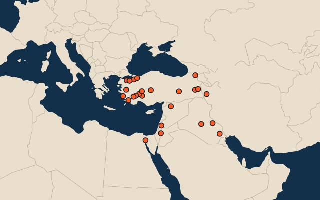
On the map
More in Middle East
- 25 largest cities in the Middle East
- Countries of the Middle East
- 25 largest lakes in the Middle East
- 25 longest rivers in the Middle East
- 25 highest peaks in the Middle East
- 25 largest islands in the Middle East
- 25 largest islands in the Middle East
Similar quizzes
- 12 largest lakes in the Andes
- 9 largest lakes in the Rocky Mountains
- 21 largest lakes in the Appalachian Mountains
- 25 largest lakes in the Scandinavian Mountains
- 13 largest lakes in the Coast Mountains
- 16 largest lakes in the Alps
- 6 largest lakes in the Sierra Madre del Sur
- 10 largest lakes in the Southern Alps
- 8 largest lakes in the Congo basin
- 25 largest lakes in the Mississippi basin
- Largest lakes