GeotchaA geography quiz on a real globe
25 largest islands in Russia
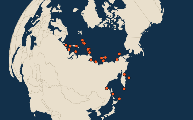
25 islands, each one drawn on a satellite globe. Name it when it lights up, find it when you are given its name, or type every one you can remember in Name all.
Free to start: a few quizzes a day cost nothing, and Geotcha Plus opens every quiz. What you miss comes back for review until it sticks.
The full list
About this quiz
Sakhalin is the largest of the 25 islands in this quiz, at 72,492 km²; Pioneer Island is the smallest listed, at 1,527 km². Sakhalin's area is 1.5 times Severny Island's (47,079 km²). The three largest hold 57% of the combined area of all 25.
What they are known for
- Sakhalin: Long Russian island north of Japan, once split between the two countries, with oil and gas offshore.
- Severny Island: The larger of a Russian Arctic archipelago's two big islands, where the Tsar Bomba, the biggest nuclear bomb ever, was set off in 1961.
- Yuzhny Island: The smaller of a Russian Arctic archipelago's two big islands, with the Belushya Guba base; the Matochkin Shar strait divides it from its twin.
- Kotelny Island: Arctic island of the New Siberian group, joined to its neighbour by the sandy flats of Bunge Land.
- October Revolution Island: Central island of an archipelago discovered only in 1913, with the Vavilov ice cap.
- Bolshevik Island: Second-largest island of Severnaya Zemlya, closest to the Asian mainland.
- Komsomolets Island: Northernmost island of Severnaya Zemlya, mostly covered by the Academy of Sciences ice cap.
- Wrangel Island: Last refuge of woolly mammoths, which survived here until about 4,000 years ago; polar bears den here in numbers.
The islands
- 1Sakhalin72,492 km²
- 2Severny Island47,079 km²
- 3Yuzhny Island33,275 km²
- 4Kotelny Island23,200 km²
- 5October Revolution Island14,204 km²
- 6Bolshevik Island11,206 km²
- 7Komsomolets Island9,006 km²
- 8Wrangel Island7,600 km²
- 9Arga-Muora-Sise6,400 km²
- 10New Siberia6,201 km²
- 11Kolguyev Island5,200 km²
- 12Bolshoy Lyakhovsky Island5,157 km²
- 13Vaygach Island3,329 km²
- 14Iturup3,167 km²
- 15Zemlya Georga2,821 km²
- 16Paramushir2,471 km²
- 17Karaginsky Island2,404 km²
- 18Wilczek Land2,203 km²
- 19Ayon Island2,000 km²
- 20Bely Island1,810 km²
- 21Bolshoy Shantar1,766 km²
- 22Bigger Begichev Island1,764 km²
- 23Bering Island1,667 km²
- 24Graham Bell Island1,557 km²
- 25Pioneer Island1,527 km²
On the map
All of Europe
More in Russia
- 25 largest cities in Russia
- Regions of Russia
- 25 largest lakes in Russia
- 25 longest rivers in Russia
- 25 highest peaks in Russia
- 25 best known World Heritage Sites in Russia
- Flags of the regions of Russia
- 10 largest cities in Russia
- 10 most populous regions of Russia
- 10 best known plains in Russia
In the regions of Russia
- 25 largest islands in Arkhangelskaya
- 7 largest islands in Chukotka
- 6 largest islands in Karelia, Russia
- 10 largest islands in Leningradskaya Oblast'
- 18 largest islands in Sakha
- 25 largest islands in Sakhalin
- 6 largest islands in St.-Petersburg
- 25 largest islands in Krasnoyarsk Krai
Other countries of Europe
- 18 largest islands in the Faroe Islands
- 8 largest islands in Malta
- 25 largest islands in Germany
- 25 largest islands in Italy
- 25 largest islands in France
- 25 largest islands in the United Kingdom
- 25 largest islands in Spain
- 6 largest islands in Poland
The whole world
How the figures are measured
Land area in km²: the Largest Islands set’s figure for its islands, else Wikidata’s (P2046) where it fits the outline, else the area of the outline. Every island Natural Earth draws at 1:10m that Wikidata names, of 5 km² or more (smaller ones when well known), and every island of the Largest Islands set. Countries are those the island’s land lies in, from the outlines.