GeotchaA geography quiz on a real globe
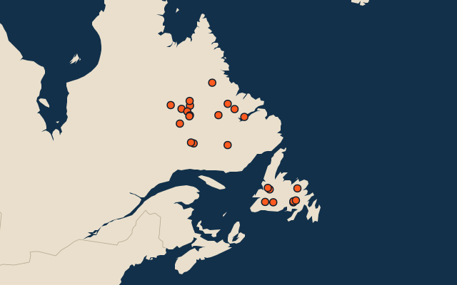
24 largest lakes in Newfoundland and Labrador
24 lakes, each one drawn on a satellite globe. Name it when it lights up, find it when you are given its name, or type every one you can remember in Name all.
Free to start: a few quizzes a day cost nothing, and Geotcha Plus opens every quiz. What you miss comes back for review until it sticks.
The full list
About this quiz
Lake Melville is the largest of the 24 lakes in this quiz, at 3,069 km²; Eastern Meelpaeg is the smallest listed, at 23 km². Lake Melville's area is 5.9 times Ashuanipi Lake's (517 km²). The three largest hold 71% of the combined area of all 24.
What they are known for
- Lake Melville: Brackish Labrador inlet joined to the Atlantic through a narrow strait.
The lakes
- 1Lake Melville3,069 km²
- 2Ashuanipi Lake517 km²
- 3Grand Lake485 km²
- 4Shabogamo Lake284 km²
- 5Mistastin Lake145 km²
- 6Lac Fleur-de-May115 km²
- 7Gander Lake113 km²
- 8Wade Lake102 km²
- 9Nipishish Lake100 km²
- 10Sims Lake93 km²
- 11Snegamook Lake81 km²
- 12Deer Lake68 km²
- 13Lac Assigny63 km²
- 14Lac du Sable62 km²
- 15McKay Lake (Newfoundland and Labrador)55 km²
- 16Andr Lake53 km²
- 17Granite Lake51 km²
- 18Disappointment Lake49 km²
- 19Fonteneau Lake46 km²
- 20King George IV Lake40 km²
- 21Colville Lake (Newfoundland and Labrador)33 km²
- 22Jubilee Lake (Canada)28 km²
- 23Kaegudeck Lake27 km²
- 24Eastern Meelpaeg23 km²
On the map
All of Canada
More in Newfoundland and Labrador
- 10 largest cities in Newfoundland and Labrador
- 12 longest rivers in Newfoundland and Labrador
- 25 largest islands in Newfoundland and Labrador
Elsewhere in Canada
- 25 largest lakes in Alberta
- 25 largest lakes in British Columbia
- 25 largest lakes in Manitoba
- 25 largest lakes in Ontario
- 25 largest lakes in Quebec
- 25 largest lakes in Saskatchewan
- 10 largest lakes in Yukon
- 25 largest lakes in Northwest Territories
Canada, by kind
- 25 largest cities in Canada
- Provinces and territories of Canada
- 25 longest rivers in Canada
- 25 highest peaks in Canada
The whole world
How the figures are measured
Lakes by surface area in km². The Caspian Sea counts as a lake. Coastal lagoons do not, and a salt pan that is dry most years (Lake Eyre) is not ranked by size. A lake belongs to every country on its shores. Natural lakes only: reservoirs held back by a dam are left out. An item counts for every first-level unit (state, province, county) it touches: a lake or island by its outline, within about 1.5 km; a river by its course, when 10 km of it (3% of a shorter river) lies in or along the unit; a summit, a cape or anything without a shape by its point.