GeotchaA geography quiz on a real globe
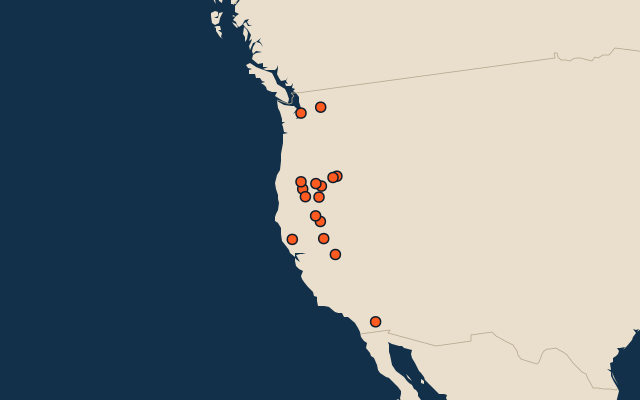
16 largest lakes in the US West Coast
16 lakes, each one drawn on a satellite globe. Name it when it lights up, find it when you are given its name, or type every one you can remember in Name all.
Free to play, with no account needed. What you miss comes back for review until it sticks.
The lakes
- 1Salton Sea888 km²
- 2Lake Tahoe502 km²
- 3Goose Lake380 km²
- 4Upper Klamath Lake250 km²
- 5Malheur Lake201 km²
- 6Honey Lake190 km²
- 7Mono Lake180 km²
- 8Clear Lake177 km²
- 9Harney Lake164 km²
- 10Lake Abert154 km²
- 11Summer Lake153 km²
- 12Lake Chelan135 km²
- 13Eagle Lake97 km²
- 14Lake Washington88 km²
- 15Lower Klamath Lake87 km²
- 16Crater Lake53 km²
Surface area in km²: the Largest Lakes set’s figure for its lakes, else Wikidata’s (P2046) where it fits the outline, else the area of the outline. Seasonal salt pans keep their recorded figure; their area varies. Every named lake Natural Earth maps at 1:10m (with its supplements for Europe, North America and Australia), and every lake of the Largest Lakes set. The Caspian Sea counts as a lake, as in that set; coastal lagoons (the Vistula Lagoon, the Black Sea limans) do not. Countries are those on its shores, from the outlines. Natural lakes only: reservoirs (artificial lakes behind a dam, as Natural Earth or Wikidata mark them) are left out. The US West Coast: California, Oregon and Washington. Places are by geography: what lies in a dependency counts for its own region (Puerto Rico’s islands are the Caribbean’s, Réunion’s Africa’s), and Hawaii is in Polynesia.
On the map
More in US West Coast
- 25 largest cities in the US West Coast
- 25 largest lakes and reservoirs in the US West Coast
- 25 longest rivers in the US West Coast
- 25 highest peaks in the US West Coast
- 25 largest islands in the US West Coast
Similar quizzes
- 25 largest lakes in the northern hemisphere
- Lakes in the northern hemisphere among the world’s 100 largest
- 25 largest lakes in the southern hemisphere
- 25 largest lakes in the eastern hemisphere
- Lakes in the eastern hemisphere among the world’s 100 largest
- Lakes in the western hemisphere among the world’s 100 largest
- 25 largest lakes in the tropics
- Lakes in the tropics among the world’s 100 largest
- 25 largest lakes in the Arctic
- 13 largest lakes in northwest China
- Largest lakes