GeotchaA geography quiz on a real globe
10 most populous provinces of Turkey
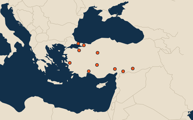
10 provinces, each one drawn on a satellite globe. Name it when it lights up, find it when you are given its name, or type every one you can remember in Name all.
Free to start: a few quizzes a day cost nothing, and Geotcha Plus opens every quiz. What you miss comes back for review until it sticks.
The full list
About this quiz
Istanbul is the largest of the 10 provinces in this quiz, at 16.7 M; Şanlıurfa is the smallest listed, at 1.9 M. Istanbul's population is about three times Ankara's (5.7 M). The three largest hold 61% of the combined population of all 10.
What they are known for
- Istanbul: The city straddling Europe and Asia on the Bosphorus, with Hagia Sophia, the Blue Mosque and the Grand Bazaar.
- Ankara: Capital of the republic, with Atatürk's mausoleum, Hittite Museum, citadel and soft-haired goats.
- İzmir: Aegean port city with Kemeraltı bazaar, a clock tower on Konak square and ancient Ephesus nearby.
- Bursa: First Ottoman capital, below snowy Uludağ ski mountain, famed for iskender kebab, silk and chestnut candy.
- Antalya: Turkish Riviera with Roman ruins at Perge and Aspendos, sandy beaches and Taurus mountains behind.
- Konya: Central Anatolian grain heartland, home of Rumi, the whirling dervishes and the Çatalhöyük Neolithic settlement.
- Gaziantep: Southeastern pistachio and baklava capital, with a huge Roman mosaic museum at Zeugma.
- Adana: Southern city of kebab on a river, with huge cotton fields on the Çukurova plain.
The provinces
- 1Istanbul16.7 M
- 2Ankara5.7 M
- 3İzmir4.5 M
- 4Bursa3.1 M
- 5Antalya2.9 M
- 6Konya2.5 M
- 7Gaziantep2.3 M
- 8Adana2.2 M
- 9Kocaeli2 M
- 10Şanlıurfa1.9 M
On the map
All of Asia
More in Turkey
- 21 largest lakes in Turkey
- 25 highest peaks in Turkey
- 25 largest cities in Turkey
- Provinces of Turkey
- 25 longest rivers in Turkey
- 23 largest islands in Turkey
- 19 best known World Heritage Sites in Turkey
- 10 largest cities in Turkey
- Districts of Turkey
- Cities ranked 26–50 in Turkey
In the regions of Turkey
- Districts of Adıyaman
- Districts of Afyonkarahisar
- Districts of Ağrı
- Districts of Amasya
- Districts of Antalya
- Districts of Artvin
- Districts of Aydın
- Districts of Balıkesir
Other countries of Asia
- States of India
- 10 most populous states of India
- Districts of India
- 25 most populous districts of India
- Provinces of China
- 10 most populous provinces of China
- Prefectures of China
- 25 most populous prefectures of China
How the figures are measured
First-level units: the 81 provinces; the 973 districts are the second level. Population of each region: a 2025 estimate: the latest official figure (a census or an estimate, as each item names it) scaled with the rest of its country’s regions to the World Bank’s 2025 national total, so a country’s regions share one year. Each item names its source and year. Regions without a figure are left out.