GeotchaA geography quiz on a real globe
Countries of the world in 1960
114 countries, each one drawn on a satellite globe. Name it when it lights up, find it when you are given its name, tell its flag from three others, or type every one you can remember in Name all.
Free to play, with no account needed. What you miss comes back for review until it sticks.
The countries
- 1Soviet Union22,129,470 km²
- 2Australia13,397,524 km²
- 3United States9,872,690 km²
- 4Canada9,868,014 km²
- 5People's Republic of China9,372,359 km²
- 6Republic of China9,147,539 km²
- 7Brazil8,531,202 km²
- 8India3,158,454 km²
- 9France2,997,502 km²
- 10Argentina2,781,932 km²
- 11Sudan2,509,747 km²
- 12Republic of the Congo2,503,099 km²
- 13Congo-Léopoldville2,340,550 km²
- 14Denmark2,297,637 km²
- 15Greenland2,153,240 km²
- 16Union of South Africa2,047,171 km²
- 17Bolivia1,964,579 km²
- 18Mexico1,961,404 km²
- 19Saudi Arabia1,956,248 km²
- 20Indonesia1,887,910 km²
- 21Iran1,623,918 km²
- 22Libya1,621,921 km²
- 23Mongolian People's Republic1,554,750 km²
- 24Mali Federation1,452,204 km²
- 25Portugal1,396,277 km²
- 26Peru1,300,262 km²
- 27Colombia1,271,252 km²
- 28Federation of Rhodesia and Nyasaland1,264,623 km²
- 29Ethiopian–Eritrean Federation (1952-1962)1,252,403 km²
- 30United Arab Republic1,189,003 km²
- 31Pakistan1,010,962 km²
- 32Venezuela914,079 km²
- 33Spain852,198 km²
- 34Turkey780,291 km²
- 35Chile737,531 km²
- 36Territorio Nacional de la Tierra del Fuego, Antártida e Islas del Atlántico Sur703,517 km²
- 37Paraguay690,399 km²
- 38Thailand686,671 km²
- 39Morocco683,084 km²
- 40Burma663,107 km²
- 41Ecuador658,348 km²
- 42Kingdom of Afghanistan641,909 km²
- 43Somali Republic639,204 km²
- 44Malagasy Republic594,392 km²
- 45Kingdom of the Netherlands592,709 km²
- 46Cameroon467,967 km²
- 47Sweden443,785 km²
- 48Iraq440,504 km²
- 49Finland391,016 km²
- 50Norway378,246 km²
- 51Japan (1953-1968)367,223 km²
- 52Poland311,399 km²
- 53Italy300,020 km²
- 54Philippines290,032 km²
- 55Uruguay286,290 km²
- 56New Zealand269,795 km²
- 57FPR of Yugoslavia253,886 km²
- 58West Germany247,599 km²
- 59Guinea245,564 km²
- 60Ghana240,599 km²
and 54 more, all in the quiz.
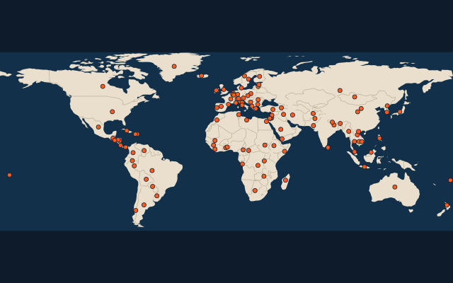
The map as it stood on 1 July 1960 (a year means its 1 July), with the names of the time. Sovereign states as they were then; British dominions count from the Statute of Westminster (1931), Egypt from 1922. Colonies, protectorates and mandates are not countries here: they have quizzes of their own. Area in km², measured on the largest of its outlines (simplified, clipped to land). Sources: OpenHistoricalMap contributors (CC0), Wikidata (CC0).
On the map
More of the world
- 25 largest cities in the world
- 25 largest countries in the world
- 50 largest regions in the world
- 25 largest lakes in the world
- 25 longest rivers in the world
- 25 highest peaks in the world
- 25 largest islands in the world
- 25 longest fjords in the world
- Flags of the world
- 50 largest cities in the world
Similar quizzes
- Countries formerly held by the Soviet Union
- Countries formerly held by France
- Countries with parts formerly held by France
- Countries formerly held by the United Kingdom
- Countries with parts formerly held by the United Kingdom
- Countries with parts formerly held by Russia
- Countries formerly held by the Ottoman Empire
- Countries with parts formerly held by the Ottoman Empire
- Countries with parts formerly held by Austria
- Countries with parts formerly held by Hungary
- Countries of the world