GeotchaA geography quiz on a real globe
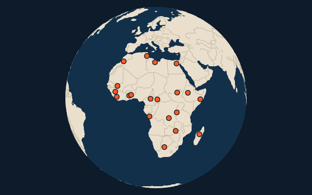
Countries of Africa in 1960
20 countries, each one drawn on a satellite globe. Name it when it lights up, find it when you are given its name, or type every one you can remember in Name all.
Free to play, with no account needed. What you miss comes back for review until it sticks.
The countries
- 1Sudan2,509,747 km²
- 2Republic of the Congo2,503,099 km²
- 3Congo-Léopoldville2,340,550 km²
- 4Union of South Africa2,047,171 km²
- 5Libya1,621,921 km²
- 6Mali Federation1,452,204 km²
- 7Federation of Rhodesia and Nyasaland1,264,623 km²
- 8Ethiopian–Eritrean Federation (1952-1962)1,252,403 km²
- 9United Arab Republic1,189,003 km²
- 10Morocco683,084 km²
- 11Somali Republic639,204 km²
- 12Malagasy Republic594,392 km²
- 13Cameroon467,967 km²
- 14Guinea245,564 km²
- 15Ghana240,599 km²
- 16Tunisia157,732 km²
- 17Liberia96,160 km²
- 18Togo56,869 km²
- 19Ruanda-Urundi52,303 km²
- 20Protectorate of the Portuguese Congo7,988 km²
The map as it stood on 1 July 1960 (a year means its 1 July), with the names of the time. Sovereign states as they were then; British dominions count from the Statute of Westminster (1931), Egypt from 1922. Colonies, protectorates and mandates are not countries here: they have quizzes of their own. Area in km², measured on the largest of its outlines (simplified, clipped to land). Sources: OpenHistoricalMap contributors (CC0), Wikidata (CC0).
On the map
More in Africa
- 25 largest cities in Africa
- Countries of Africa
- 25 largest regions in Africa
- 25 largest lakes in Africa
- 25 longest rivers in Africa
- 25 highest peaks in Africa
- 25 largest islands in Africa
- 25 best known peoples in Africa
- Flags of Africa
- Cities ranked 26–50 in Africa
Similar quizzes
- Countries formerly held by the Soviet Union
- Countries formerly held by France
- Countries with parts formerly held by France
- Countries formerly held by the United Kingdom
- Countries with parts formerly held by the United Kingdom
- Countries with parts formerly held by Russia
- Countries formerly held by the Ottoman Empire
- Countries with parts formerly held by the Ottoman Empire
- Countries with parts formerly held by Austria
- Countries with parts formerly held by Hungary
- Countries of the world