GeotchaA geography quiz on a real globe
25 largest cities in the North European Plain
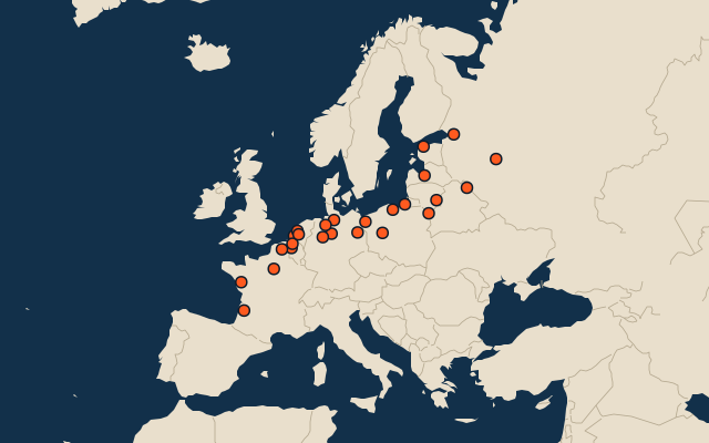
25 cities, each one drawn on a satellite globe. Name it when it lights up, find it when you are given its name, tell its flag from three others, or type every one you can remember in Name all.
Free to start: a few quizzes a day cost nothing, and Geotcha Plus opens every quiz. What you miss comes back for review until it sticks.
The full list
About this quiz
Paris is the largest of the 25 cities in this quiz, at 11.6 M; Vilnius is the smallest listed, at 337 k. Paris's population is 1.8 times Saint Petersburg's (6.4 M). The three largest hold 49% of the combined population of all 25. They lie in ten countries; Germany has the most, with six.
What they are known for
- Berlin: Includes Potsdam.
- Rotterdam: Includes The Hague.
- Lille: Includes Mouscron.
- Hanover: Includes Hildesheim.
- Bielefeld: Includes Gütersloh, Herford.
The cities
- 1Paris France11.6 M
- 2Saint Petersburg Russia6.4 M
- 3Berlin Germany4.7 M
- 4Rotterdam Netherlands3.5 M
- 5Hamburg Germany2.9 M
- 6Brussels Belgium2.8 M
- 7Amsterdam Netherlands2.6 M
- 8Lille France1.3 M
- 9Antwerp Belgium1.3 M
- 10Bordeaux France1.2 M
- 11Hanover Germany1.1 M
- 12Bielefeld Germany1.1 M
- 13Riga Latvia549 k
- 14Utrecht Netherlands522 k
- 15Duisburg Germany501 k
- 16Poznan Poland494 k
- 17Nantes France454 k
- 18Tallinn Estonia438 k
- 19Kaliningrad Russia436 k
- 20Bremen Germany422 k
- 21Gdańsk Poland385 k
- 22Hrodna Belarus374 k
- 23Tver Russia367 k
- 24Vitebsk Belarus361 k
- 25Vilnius Lithuania337 k
On the map
More in North European Plain
Similar quizzes
- 25 largest cities in the Amazon basin
- 25 largest cities in the Congo basin
- 25 largest cities in the Mississippi basin
- 25 largest cities in the Ob basin
- 25 largest cities in the Río de la Plata basin
- 25 largest cities in the Nile basin
- 25 largest cities in the Yenisei basin
- 12 largest cities in the Lena basin
The whole world
How the figures are measured
Population of the metro area: the city and the places continuously built up around it, as Thomas Brinkhoff’s Major Agglomerations of the World (citypopulation.de) counts them from censuses projected to 1 January 2026, the list most rankings use. It covers every agglomeration of 1 million or more; below that, a city ranks by its urban centre in the United Nations’ World Urbanization Prospects 2025 at 1 January 2026 (every city of 300,000 or more and every capital, counted by the Degree of Urbanisation on a 1 km grid), and a smaller city by its city-proper figure. Each source agglomeration is counted once: its main city and named core cities are accepted answers for the same entry. The included core cities are listed on its card. These agglomerations are not official US metropolitan statistical areas. Cities of the polycentric regions excluded from this source list still rank by their own figures. The North European Plain: what lies inside the plain’s outline, by each item’s point (a lake’s centre, a river’s mouth, a summit).