GeotchaA geography quiz on a real globe
25 countries in the world with the lowest average temperature
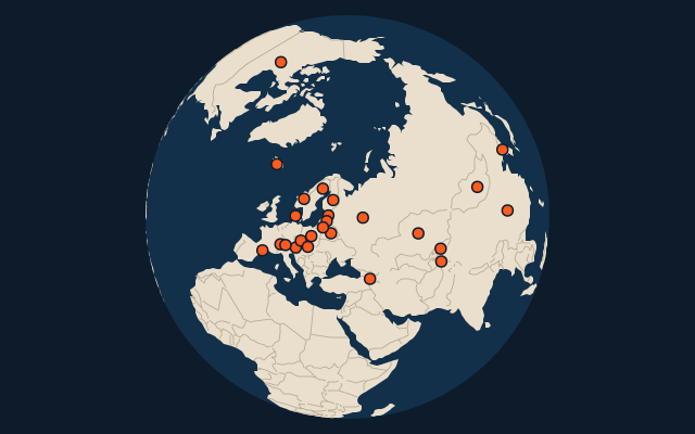
25 countries, each one drawn on a satellite globe. Name it when it lights up, find it when you are given its name, tell its flag from three others, or type every one you can remember in Name all.
Free to start: a few quizzes a day cost nothing, and Geotcha Plus opens every quiz. What you miss comes back for review until it sticks.
The full list
About this quiz
The quiz covers 25 countries, from Russia and Canada to Denmark.
What they are known for
- Russia: The world’s lowest average temperature
- Canada: Maple leaf flag, ice hockey, Niagara Falls shared with its southern neighbour and a vast Arctic archipelago.
- Mongolia: Birthplace of Genghis Khan, where nomads live in round felt gers on the steppe.
- Kyrgyzstan: Mountain nomads sleep in yurts, and its great alpine lake never freezes despite the altitude.
- Norway: Fjords, the midnight sun and the Nobel Peace Prize, awarded in Oslo.
- Iceland: Geysers, the Blue Lagoon and the northern lights, on a volcanic island straddling two tectonic plates.
- Finland: Saunas, thousands of lakes and Santa's Lapland, with Helsinki on the Gulf.
- Sweden: Home of ABBA, flat-pack furniture and the Nobel Prizes, with a capital spread over islands.
The countries
- 1Russia−3.8 °C
- 2Canada−3.5 °C
- 3Mongolia1 °C
- 4Kyrgyzstan1.2 °C
- 5Norway1.2 °C
- 6Iceland2.4 °C
- 7Finland2.6 °C
- 8Sweden3.4 °C
- 9Tajikistan3.5 °C
- 10Andorra4.9 °C
- 11Switzerland6.2 °C
- 12Estonia6.3 °C
- 13Latvia6.6 °C
- 14North Korea6.8 °C
- 15Armenia6.9 °C
- 16Kazakhstan6.9 °C
- 17Belarus7 °C
- 18Lithuania7.2 °C
- 19Austria7.3 °C
- 20China7.4 °C
- 21Liechtenstein7.6 °C
- 22Czechia8.4 °C
- 23Poland8.7 °C
- 24Slovakia8.7 °C
- 25Denmark8.8 °C
On the map
More of the world
- 25 largest cities in the world
- 25 largest countries in the world
- 50 largest regions in the world
- 25 largest lakes in the world
- 25 longest rivers in the world
- 25 highest peaks in the world
- 25 largest islands in the world
- 25 longest fjords in the world
- Flags of the world
- 50 largest cities in the world
The whole world
How the figures are measured
Mean annual air temperature in °C, averaged over the whole country (every 9 km cell of the climate grid inside its outline, weighted by area), 1991-2020: TerraClimate, the mean of the monthly daily maximum and minimum. A figure for the land as a whole, so a mountain country is cooler than its capital. Each item names its year; a country without a recent figure is left out.