GeotchaA geography quiz on a real globe
25 countries in the world with the least rainfall
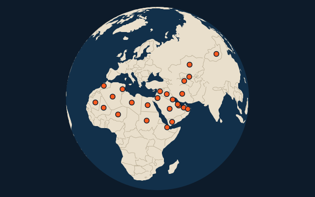
25 countries, each one drawn on a satellite globe. Name it when it lights up, find it when you are given its name, tell its flag from three others, or type every one you can remember in Name all.
Free to start: a few quizzes a day cost nothing, and Geotcha Plus opens every quiz. What you miss comes back for review until it sticks.
The full list
About this quiz
The quiz covers 25 countries, from Egypt and Libya to Morocco.
What they are known for
- Egypt: The least rainfall in the world
- Libya: Ruled by Muammar Gaddafi for 42 years, with Roman Leptis Magna on its coast.
- Algeria: Largest country in Africa, with over 80 percent of it Sahara.
- United Arab Emirates: Seven sheikhdoms federated, among them Dubai with the Burj Khalifa.
- Qatar: Hosted the 2022 football World Cup, the first Arab country to do so.
- Mauritania: Home of the Richat Structure, the 'Eye of the Sahara', and some of the world's longest trains.
- Bahrain: Pearl divers made it rich before oil, and a causeway now links it to its giant neighbour.
- Saudi Arabia: Holds Mecca and Medina, Islam's holiest cities, and has no permanent river.
The countries
- 1Egypt17 mm
- 2Libya27 mm
- 3Algeria72 mm
- 4United Arab Emirates73 mm
- 5Qatar79 mm
- 6Mauritania81 mm
- 7Bahrain82 mm
- 8Saudi Arabia94 mm
- 9Oman95 mm
- 10Yemen96 mm
- 11Jordan103 mm
- 12Kuwait127 mm
- 13Niger132 mm
- 14Djibouti139 mm
- 15Turkmenistan148 mm
- 16Mongolia173 mm
- 17Uzbekistan187 mm
- 18Sudan194 mm
- 19Iraq204 mm
- 20Tunisia213 mm
- 21Iran227 mm
- 22Kazakhstan237 mm
- 23Syria241 mm
- 24Mali260 mm
- 25Morocco263 mm
On the map
More of the world
- 25 largest cities in the world
- 25 largest countries in the world
- 50 largest regions in the world
- 25 largest lakes in the world
- 25 longest rivers in the world
- 25 highest peaks in the world
- 25 largest islands in the world
- 25 longest fjords in the world
- Flags of the world
- 50 largest cities in the world
The whole world
How the figures are measured
Mean annual precipitation (rain and melted snow) in mm, averaged over the whole country (every 9 km cell of the climate grid inside its outline, weighted by area), 1991-2020: TerraClimate. A figure for the land as a whole, so it hides the wet side of a mountain range and its dry side. Each item names its year; a country without a recent figure is left out.