GeotchaA geography quiz on a real globe
25 countries in the world with the highest average temperature
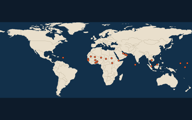
25 countries, each one drawn on a satellite globe. Name it when it lights up, find it when you are given its name, tell its flag from three others, or type every one you can remember in Name all.
Free to start: a few quizzes a day cost nothing, and Geotcha Plus opens every quiz. What you miss comes back for review until it sticks.
The full list
About this quiz
The quiz covers 25 countries, from the Maldives and Mali to Antigua and Barbuda.
What they are known for
- Maldives: The world’s highest average temperature
- Mali: Timbuktu, the fabled desert city, and the medieval empire of Mansa Musa.
- United Arab Emirates: Seven sheikhdoms federated, among them Dubai with the Burj Khalifa.
- Burkina Faso: Landlocked Sahel state whose capital, Ouagadougou, hosts a pan-African film festival.
- Djibouti: Several foreign navies keep bases here, at the strait guarding the Red Sea's southern entrance.
- Senegal: Its capital marks Africa's westernmost mainland point, with a thin neighbour running into its middle.
- Mauritania: Home of the Richat Structure, the 'Eye of the Sahara', and some of the world's longest trains.
- Niger: Landlocked Sahel state, mostly desert, named for a great river that only crosses its corner.
The countries
- 1Maldives29.2 °C
- 2Mali29 °C
- 3United Arab Emirates28.9 °C
- 4Burkina Faso28.5 °C
- 5Djibouti28.5 °C
- 6Senegal28.4 °C
- 7Mauritania28.3 °C
- 8Niger28 °C
- 9Oman27.9 °C
- 10Chad27.8 °C
- 11Gambia27.7 °C
- 12South Sudan27.7 °C
- 13Benin27.6 °C
- 14Qatar27.6 °C
- 15Ghana27.5 °C
- 16Marshall Islands27.5 °C
- 17Sudan27.5 °C
- 18Cambodia27.4 °C
- 19Brunei27.3 °C
- 20Nauru27.3 °C
- 21Micronesia27.2 °C
- 22Togo27.2 °C
- 23Guinea-Bissau27.1 °C
- 24Singapore27.1 °C
- 25Antigua and Barbuda27 °C
On the map
More of the world
- 25 largest cities in the world
- 25 largest countries in the world
- 50 largest regions in the world
- 25 largest lakes in the world
- 25 longest rivers in the world
- 25 highest peaks in the world
- 25 largest islands in the world
- 25 longest fjords in the world
- Flags of the world
- 50 largest cities in the world
The whole world
How the figures are measured
Mean annual air temperature in °C, averaged over the whole country (every 9 km cell of the climate grid inside its outline, weighted by area), 1991-2020: TerraClimate, the mean of the monthly daily maximum and minimum. A figure for the land as a whole, so a mountain country is cooler than its capital. Each item names its year; a country without a recent figure is left out.